

Latest Weather Blog
Wednesday AM Forecast: Isolated showers and thunderstorms expected this afternoon
A greater coverage for rain is expected today as a weak cold front makes its way into the area. Because it is so weak, the front will not impact our temperatures and dew points over the next few days.
Today & Tonight: A weak disturbance in the atmosphere and its associated front will move into the area today. As it moves through SE Louisiana, it will stir up isolated showers and thunderstorms, especially during the afternoon hours. High temperatures will make it into the low to mid 90s ahead of any precipitation. Tonight, the chance for rain reduces after sunset and we will be left with partly cloudy skies and an overnight low in the lower 70s.
Up Next: Through the end of the workweek, a decaying front will meander near the Gulf Coast. Though no single day looks particularly busy, the front warrants mention of a spotty, afternoon shower or thunderstorm. Coastal areas stand the best chance to see some rain. Otherwise, expect partly sunny skies with highs in the low 90s and lows in the low 70s. Another front will push in for the weekend and should bring a better shot at showers and thunderstorms on Saturday. Dry air tailing this front will bring another pop of lower humidity! In fact, there is a chance we could register our first high temperature in the 80s since May 27.
Get the latest 7-day forecast and real time weather updates HERE.
Watch live news HERE.
Trending News
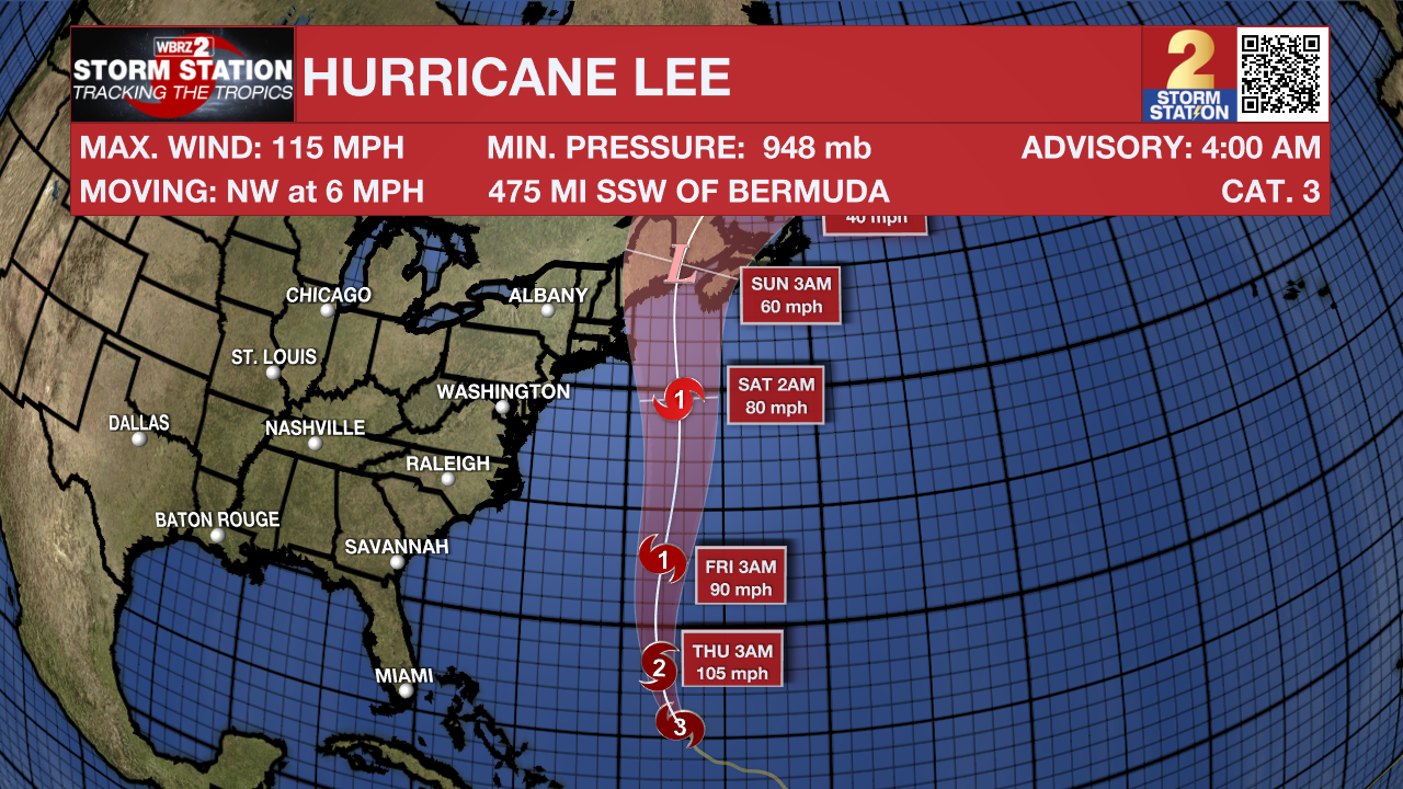
The Tropics: Hurricane Lee remains a major hurricane across the southwest Atlantic Ocean. The storm is expected to strengthen a bit more while turning north followed by gradual weakening. Lee is expected to pass near, but to the west, of Bermuda in a few days. Dangerous surf is expected all across the Atlantic Seaboard.
Hurricane Margot continues to chug north across the eastern Atlantic Ocean at 14mph. With maximum sustained winds of 85mph, the storm will maintain a similar intensity over the next several days. A north-northwestward or northward motion with a gradual decrease in forward speed is expected through early Thursday. Then, Margot is likely to stall or meander within weak steering currents into the weekend.
A broad area of low pressure over the eastern tropical Atlantic continues to produce disorganized showers and thunderstorms. This system is expected to consolidate, with a low on the western side becoming dominant over the next day or two. Gradual development of the low is expected after that, and there is an eighty percent chance that a tropical depression is likely to form by this weekend while the system moves west-northwestward or northwestward at about 15 mph across the central tropical Atlantic.
--Emma Kate
The Storm Station is here for you, on every platform. Your weather updates can be found on News 2, wbrz.com, and the WBRZ WX App on your Apple or Android device. Follow WBRZ Weather on Facebook and Twitter for even more weather updates while you are on the go.
More News
