Moving to a more active pattern and the official hurricane season
As the 2016 hurricane season “officially” begins today, two storm names are already in the books—Alex and Bonnie. Colin is up next. All is quiet for now, but it only takes one storm to make it a “bad” year. Our team is happy to prepare you for the season ahead, check out our hour long special RIGHT HERE.
THE FORECAST:
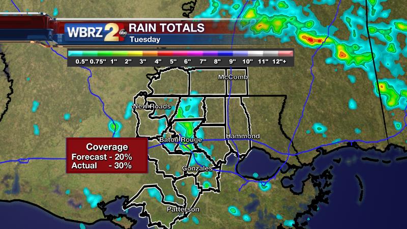
Today and Tonight: Wednesday will be partly sunny and humid with a high temperature near 90 degrees. An afternoon shower or thunderstorm is possible, but rain coverage around the forecast area is again expected to be low. On Tuesday, 20% coverage was anticipated. About 30% of the 13 Parish, 3 County forecast area found measurable rain, primarily in East Baton Rouge and East Feliciana Parishes. Overnight, skies will be partly cloudy. It will stay muggy with a low around 70 degrees.

Up Next: Thursday will mark the transition into a more active pattern. After some early sunshine and a high pushing 90 degrees, more numerous showers and thunderstorms are expected to bubble up during the afternoon hours. Friday through Sunday will be mostly cloudy with scattered to widespread showers and thunderstorms in the late morning and afternoon. Due to increased clouds and times of rain, highs likely won’t go beyond the mid to upper 80s.
Trending News
THE SCIENCE:
Forecast Discussion: After another afternoon of limited convection, added instability, marine breezes will have an easier time setting off showers and thunderstorms during the peak heating hours of Thursday. On Friday, an upper level trough will stall over Central Texas with an associated front stretching into Louisiana. These features will place help to create active weather for the remainder of the extended forecast. Showers and thunderstorms will be triggered by the front, enhanced by marine breezes and grow a little more robust in strength and coverage due to more unstable atmosphere in place on account of the trough. While much of the action will thrive on warmth, some waves of vorticity in the mean flow could activate some nocturnal storms as well. However, those rounds will be better timed as we get closer. Both major computer forecast models are continuing the unsettled pattern through the weekend, until another upper trough can snare the front and absorb the stalled trough.
--Josh
For updates, stay connected with Meteorologist Josh Eachus:


