

Latest Weather Blog
One down, so many more to go
Warmer and more humid conditions have slowly taken hold through the week. Meanwhile, showers have only been isolated and will stay that way until the early part of the weekend. The thermometer at Metro Airport in Baton Rouge was the lone gauge to strike 90 degrees on Wednesday afternoon. This first for the year came about two weeks ahead of average but is not unusual—the last two years have seen the first 90 degree day in late April and early May. The Baton Rouge area averages a little more than 90 days in the 90s each warm season.
THE FORECAST:
Today and Tonight: Thursday may be yet another repeat with only a small rain chance. If a shower can develop, north and west of Baton Rouge would be the most likely area for this to happen. High temperatures will make it into the upper 80s and the humidity will be noticeable. Overnight will be mostly cloudy with patchy fog and low temperatures near 70.
Up Next: As warmth and humidity from the Gulf remain elevated, enough instability is in place for more robust coverage in showers and thunderstorms. However, a true trigger has been lacking but this will change late Friday into Saturday. Then, a stronger upper level disturbance will increase coverage of showers and thunderstorms into the scattered category. By Sunday, activity should be more confined to coastal areas. Some thermometers could take a run at 90 degrees Sunday or Monday. LSU Baseball should not have too many worries hosting Ole Miss this weekend. Friday evening and Sunday look fine. Some rain could potentially linger for the Saturday evening contest.
Trending News
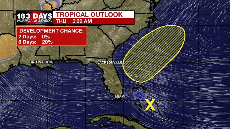
The Tropics: Even though the “official” hurricane season does not begin until June 1, as we have seen in over the last several years, a weak disturbance is having a go at organizing over the northwestern Bahamas. Some slow development is possible as the disturbance turns northeastward and moves over the western Atlantic. It will not affect the local area.
The Mississippi River: At Baton Rouge, major flood stage continues with a level of 41.5’ as of Thursday morning. Peaking at 44.1’ on March 19, the river set its 7th highest recorded crest at Baton Rouge. In addition, at 117 days this marks the second longest period above flood stage. Heavy rain north of the area will cause the river to remain steady or slowly rise through Mid-May. It does not appear that this second crest will be as high as it was in March. The high water is primarily an issue for river traffic and river islands, although some inundation will continue unprotected low-lying areas. The city of Baton Rouge and the main LSU campus are protected by levees up to 47 feet. Some soggy areas and seepage may be noted due to the long duration of high water placing pressure on the levees. As some of the Mississippi River diverts into the Atchafalaya River, gauges at Krotz Springs and Morgan City will stay high as well. This creates backwater flooding in parts of Assumption Parish in areas such as Stephensville and around Lake Palourde. Like Big Muddy, this is expected to be a prolonged event but is not uncommon for the time of year.
THE EXPLANATION:
Weak upper level troughs continue to pass just north of the local area and this has caused precipitation to miss much of the local area. All the while, an upper level ridge remains steadfast over the Southeast and this helped keep most of the action away and the temperatures high. The ridge has opened the gates to the Gulf of Mexico and surface moisture is becoming noticeable with dew point temperatures in the 70s across much of the region. All of this warmth and moisture would lead to showers and thunderstorms if not for the ridge suppressing activity. The ridge is expected to be overcome by a shortwave trough passing farther south late Friday into Saturday.
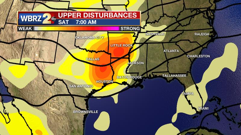
This disturbance, which shows up very clearly on vorticity (upper disturbances) models, will increase development of showers and thunderstorms. The most active period will be Saturday morning into the afternoon hours. Severe weather is not a huge concern, but remember that warm season storms can be briefly and locally strong with downpours, frequent lightning and gusty wind. There will be no clean cold frontal passage and therefore no significant change in temperatures or humidity after this activity. Sunday and Monday should work out to be drier around the region as some sinking air moves in behind the disturbance. Additionally, high temperatures may challenge the 90s before the next disturbance comes into the area again elevating rain chances. This currently appears to be in the Tuesday timeframe.
--Josh
The WBRZ Weather Team is here for you, on every platform. Your weather updates can be found on News 2, wbrz.com, and the WBRZ WX App. on Apple and Android devices. Follow WBRZ Weather on Facebook and Twitter for even more weather updates while you are on the go.
More News
