

Latest Weather Blog
Cooler and drier by afternoon, monitoring Gulf low
A cold front will return cooler, more pleasant conditions through Thursday. Some rain, possibly associated with a tropical disturbance, will return for the weekend.
THE FORECAST:
Today and Tonight: Showers and thunderstorms will end from northwest to southeast by midday. With temperatures near 70, a cold front will push through Wednesday morning. The passage will lead to gradual clearing and drying conditions. North winds will stop thermometers from moving much farther than the mid 70s. Mostly clear skies are anticipated overnight with lows in the low 50s.
Up Next: High temperatures will stay in the low-to-mid 70s through Friday. Relatively quiet weather in anticipated with some sun on Thursday. Friday will begin in the upper 50s but clouds will be increasing thanks to an area of low pressure advancing northward from the southern Gulf of Mexico. There could even be an isolated shower south and east of Baton Rouge by late in the day. This low pressure system may have some tropical characteristics and could lead to unsettled weather for the first half of the weekend prior to an even stronger cold front early next week.
Trending News
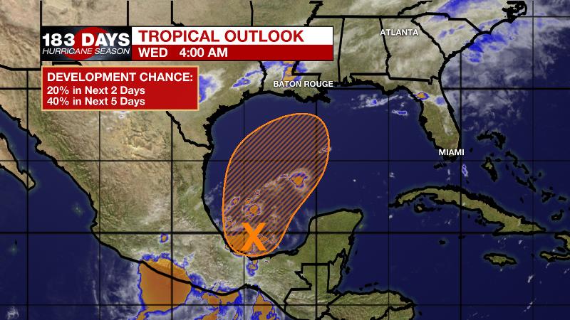
The Tropics: Tropical Depression 15 has dissipated over the Cabo Verde Islands. Closer to home, A trough of low pressure located over the Bay of Campeche is producing disorganized showers and thunderstorms. The system is forecast to emerge over the southern Gulf of Mexico and move slowly northward. Gradual development is possible, and a tropical or subtropical cyclone could form late this week over the western or central Gulf of Mexico while the system is moving generally northeastward. The National Hurricane Center gives a 40 percent chance of development. Regardless of development, a period of rain and wind will be possible along part of the central and/or eastern Gulf Coast.
THE EXPLANATION:
Showers and thunderstorms will end from northwest to southeast as a cold front and associated wind shift occur through the mid-morning hours Wednesday. Drying conditions are expected through afternoon as a surface high builds across the Mid-Mississippi River Valley. A tropical disturbance is expected to move into the western Gulf of Mexico by the end of this week. While strong westerlies will make significant tropical development difficult, those steering winds will drive this disturbance and its moisture toward the central or eastern Gulf Coast. On Friday, dry air from the surface high to the north will make it difficult for rain to develop. However, as the system moves closer to land, a plume of moisture should push inland with the possibility of heavy rainfall and strong thunderstorms on Saturday. It is still too early to pinpoint exactly where this may occur, so locations from Louisiana to Florida need to continue to monitor. By Monday night, a strong cold front will blow through and end the unsettled weather.
--Josh
The WBRZ Weather Team is here for you, on every platform. Your weather updates can be found on News 2, wbrz.com, and the WBRZ WX App. on Apple and Android devices. Follow WBRZ Weather on Facebook and Twitter for even more weather updates while you are on the go.
More News
