

Latest Weather Blog
Warm temperatures continue into early Spring
Astronomical spring begins Thursday at 10:50pm. Of course, meteorological spring began on March 1 and it has felt like spring in the Capital Area for quite some time now. The recent shower and thunderstorm activity should lessen for the next two afternoons. Well above average temperatures will continue.
THE FORECAST:
Today and Tonight: With a warm front well north of the area, southerly winds and partly sunny skies will have no trouble sending high temperatures into the low 80s. A spotty shower is not impossible, but unlikely. Overnight, partly cloudy skies will give way to some fog formation late with low temperatures in the upper 60s.
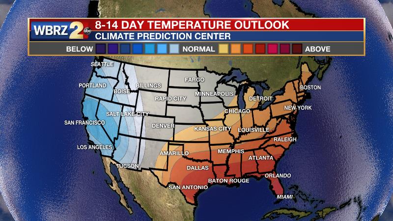
Up Next: An upper level ridge of high pressure over the northern Gulf will be shunted to the southeast by the end of the week. This shift will open the door for a cold front to creep into the area. The sensible weather will be a slow, steady increase in the number of showers and thunderstorms that develop, especially late Friday. The front will move slowly enough and with a north to south fashion such that severe weather and heavy rain are not expected. However, unsettled weather will linger through much of the weekend. The boundary will change temperatures for the cooler Saturday and Sunday before moderation occurs early next week. Per the Climate Prediction Center, the first full week of spring is looking warmer than average across the Baton Rouge area and southeast United States. For reference, average temperatures are highs in the low 70s and lows in the low 50s.
Trending News

THE EXPLANATION:
An upper level ridge of high pressure will stay anchored over the Gulf of Mexico for the next couple of days. While it has not been overly dense away from the coast, fog will continue to be an early morning issue due to high dew points and light, southerly winds. A stronger frontal system will then move from the Great Plains to the Great Lakes starting Thursday bringing some slightly better rain chances through the weekend. As of now, the upper level energy is expected to remain well north of the local area, lending to minor impacts locally. Severe weather looks unlikely and rain totals look light. By the time this front passes, cooler temperatures will arrive by the tail end of the weekend.
--Josh
The WBRZ Weather Team is here for you, on every platform. Your weather updates can be found on News 2, wbrz.com, and the WBRZ WX App. on Apple and Android devices. Follow WBRZ Weather on Facebook and Twitter for even more weather updates while you are on the go.
More News
