

Latest Weather Blog
Unseasonable warmth into the new month
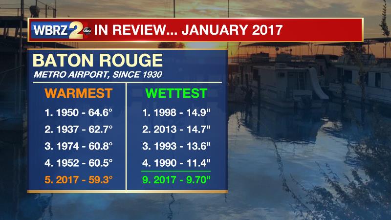
As a new month begins, the warmer pattern continues. With an average temperature of 59.3 degrees, January 2017 was the fifth warmest on record. Bumped by nearly 5 inches of rain on January 19, the month goes down as the ninth wettest with 9.7 inches. Records from Baton Rouge Metropolitan Airport date back to 1930.
THE FORECAST:
Today through Tomorrow: A partly sunny afternoon is ahead. With the continued southwesterly winds and at least some sun, high temperatures will return to the mid 70s. Overnight, clouds are expected to be more prevalent and some fog is a possibility. Lows will be in the mid to upper 50s.
Up Next: The remainder of the week will bring slight changes as a front settles into the region. Increased cloud cover is expected on both Thursday and Friday with a few showers as well. Widespread and/or heavy rain will not be an issue. Highs will be in the low to mid 70s with lows in the low to mid 50s. Over the weekend, the front will continue to weaken over the area, but some cloud cover and spotty showers will remain in the forecast. Temperatures will trend 3-5 degrees cooler.
Trending News
THE SCIENCE: For lack of a better word, upper level “troughiness” in the east and strong surface high pressure in the west is shoving a cold front southward to the Gulf Coast. A weaker surface high over Central Florida has been providing return flow for 48 hours or so and thus some patchy fog has developed. As the front nears later today and tomorrow, a few clouds may begin to develop as well. Because the approaching front will be oriented parallel to the jet stream, very slow forward progress is anticipated. Uplift and deep moisture are lacking so the perceptible weather will only be increased cloud cover with isolated showers. The front will get more of a kick through over the weekend as a shortwave moves across the middle of the country. No significant cool down is expected as the upper levels remain essentially zonal in the wake of that wave and the front will have lost most of its temperature gradient by that point. A day or two reprieve from active weather can be expected before a deeper trough is carved out for the middle and end of next week. Both forecast models are in agreement, though later now, that a storm system will move from the Gulf of Mexico to Eastern Seaboard during that time. We can expect a period of rain and possibly thunderstorms as a result.
--Josh
More News
