

Latest Weather Blog
Friday PM Forecast: humidity climbs over the weekend
After one more morning in the 60s on Friday, a slow return of humidity has begun. With this, chances for showers and thunderstorms will work back into the forecast, though nothing extensive is expected.
Next 24 Hours: Expect mainly clear skies overnight with calm winds. It is unlikely that many locations will be able to dip below 70 degrees. Humidity will make a gradual comeback on your Saturday. With this, a stray shower or thunderstorm could form in the peak heating of the afternoon hours as reach for 90 degrees.
Up Next: Standard summer fare is ahead Sunday into early next week. Expect hot and humid conditions with highs in the low 90s and lows in the mid 70s. While each day will start with plenty of sunshine, isolated showers and thunderstorms will be around to dodge in the afternoons. For the 13 Parish, 3 County Forecast Area, rain coverage will be around 20 to 40 percent Sunday through Thursday. CLICK HERE for your full 7-Day Forecast.
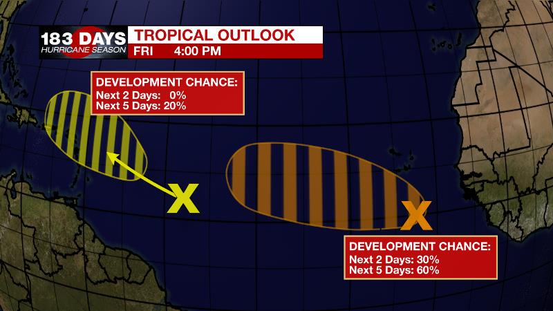
The Tropics: A large, disorganized area of clouds and showers located a few hundred miles south of the Cabo Verde Islands is associated with a tropical wave and a broad area of low pressure. Environmental conditions allow a 60 percent chance that a tropical depression could form late this weekend or early next week while the system moves generally west-northwestward across the tropical Atlantic.
Trending News
A tropical wave located over the west-central tropical Atlantic is producing limited shower activity. There is a 20 percent chance of some slow development as it moves west- northwestward and approaches the Lesser Antilles early next week.
These particular systems are more than a week away from being any concern to the United States. However, it is now the time of year when we need to start to monitor the deep tropics. For the latest tropical forecasts and information, visit the WBRZ Hurricane Center as we navigate all 183 Days of Hurricane Season.
The Explanation: Steadily, onshore flow will return to the area this weekend. As humidity builds, lake and sea breezes will lift warm inland air to allow isolated showers and thunderstorms Saturday and Sunday afternoons. Forecast models are somewhat bullish on rain coverage Monday, though they also display some upper level ridging over the area, which would tend to suppress convection. Since the ridging seems more likely, the forecast will remain consistent with just isolated, afternoon showers and thunderstorms. Through the middle of next week, surface high pressure across the western Atlantic Ocean will cause southerly flow and maintain a typically repetitive summertime pattern. Temperatures will be near average with highs in the low 90s and lows in the mid 70s. Seasonably uncomfortable humidity will be back and help to fuel isolated to perhaps scattered afternoon showers and thunderstorms.
--Josh
The WBRZ Weather Team is here for you, on every platform. Your weather updates can be found on News 2, wbrz.com, and the WBRZ WX App on your Apple or Android device. Follow WBRZ Weather on Facebook and Twitter for even more weather updates while you are on the go.
More News
