

Latest Weather Blog
Wednesday PM Forecast: one more round of fog before rain and thunderstorms
The Storm Station is tracking three impacts over the next three days. Thick morning fog and record-challenging warmth will remain possible; the workweek will end stormy thanks to a cold front, and then much cooler air will spill into the Capital Area.
A DENSE FOG ADVISORY will be in effect from midnight to 10 am Thursday, primarily for parishes south and east of Baton Rouge. Visibility of one quarter mile or less could make driving conditions hazardous. If driving, slow down, use your low beam headlights, and leave plenty of distance ahead of you.
Thursday: mild with thick morning fog
Friday: stormy
Weekend: much cooler with stubborn clouds
Tonight & Tomorrow: The fog forecast is a bit challenging due to the presence of clouds, which tend to limit formation. Mostly cloudy skies will again be possible tonight, but especially where there are gaps in the deck, patchy dense fog could develop as lows settle in the low 60s. The most widespread fog will occur during the commute times. Low visibility can cause sudden slowdowns on I-10 and I-12, so keep those low beams on and stay alert! Any fog and low clouds will break up for a few peeks of sunshine as highs head for the upper 70s and low 80s. Winds will be more noticeable on Thursday afternoon with sustained south breezes of 10-20mph and a few higher gusts. A few showers will even be possible as even muggier air moves inland from the Gulf. This will signal the arrival of our next storm system.
Trending News
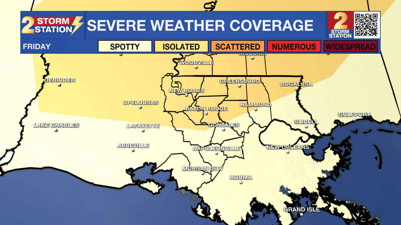
Up Next: A cold front will start to make its presence felt by Thursday night. Clouds will thicken with increasing showers and winds. While we’ll see off-and-on showers and thunderstorms during the morning and afternoon on Friday, our main concern will be Friday evening. The atmosphere will be primed for stronger thunderstorms, especially for areas north and west of Baton Rouge. We could see a line of storms capable of producing gusty winds and perhaps even a brief tornado. There is a level 2/5 "slight risk" for severe weather, meaning that isolated instances of severe weather will be possible; many will not experience severe weather, but all should prepare. Keep the WBRZ WX App handy for live radar and instant alerts. Additionally, expect wet roads and possible delays for both commutes.

The cold front will crawl through the region on Saturday, but there should still be a noticeable 10-15 degree drop in temperatures when compared to the end of the workweek. It may even feel more chilly due to north winds behind the front and lingering clouds. Spotty showers will even stay possible through the day as the upper-level energy in the atmosphere associated with the front is slow to move through.
Though the thickest clouds will be gone, skies will not fully clear for a few days, which will feel seasonably chilly. Highs will be in the 50s Sunday through Tuesday. Lows could approach freezing a few mornings early next week.
Get the latest 7-day forecast and real-time weather updates HERE.
Watch live news HERE.
– Josh
The Storm Station is here for you, on every platform. Your weather updates can be found on News 2, wbrz.com, and the WBRZ WX App on your Apple or Android device. Follow WBRZ Weather on Facebook and X for even more weather updates while you are on the go.
More News
