

Latest Weather Blog
Tuesday PM Forecast: warmer, quiet until storms arrive Thursday
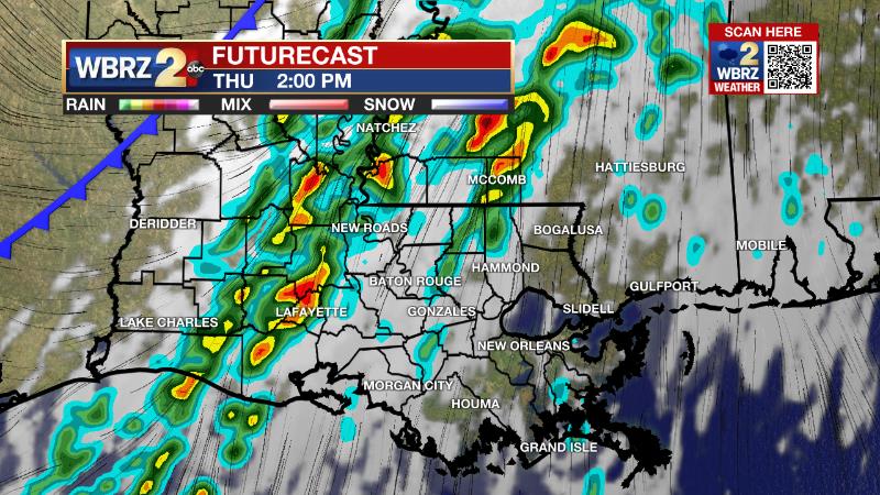
A couple of strong thunderstorms will be possible on Thursday. As expected, the most favorable ingredients will be north of Metro Baton Rouge, but enough of a reason to pay attention to the weather.
Next 24 Hours: Skies will remain mostly clear overnight. Persistent southerly winds will serve to keep low temperatures much milder than the previous two nights, with most locations stopping around 50 degrees. Some patchy fog is possible toward dawn. Transitional weather is expected on Wednesday. While skies will be partly sunny, clouds will have a tendency to increase later in the day. Enough sun will be available to help south winds send high temperatures will into the mid 70s.
Up Next: A few showers will be possible Wednesday night as cold front approaches from the west. On Thursday, morning temperatures in the mid 60s will warm just a few degrees into the mid 70s by the afternoon. Expect showers and thunderstorms to increase in advance of the front with rain chances highest immediately along the front during the afternoon hours. At that time, one or two storms could turn strong with gusty winds. Behind the cold front, temperatures will drop back below average starting Friday in the low 40s and only recovering into the 50s later in the day. Cooler temperatures will stick around Saturday as well. CLICK HERE for your detailed 7-Day Forecast.
The Explanation: By Tuesday night a surface the high pressure system will shift east and allow winds to become onshore out of the southeast. This will not only continue a warming trend in temperatures but increase moisture across the area. It is possible that the advancing moisture with cold land and lake temperatures results in a bit of fog on Wednesday morning. By Wednesday night, an upper level trough and its associated cold front will start to push in from the west allowing a few showers to develop. These showers will be shallow in the atmosphere and are unlikely to be heavy or long lasting.
Trending News
Over the last few days, the trend in forecast models has been for the upper level tough and associated surface low to pass farther and farther north of our area, in turn reducing, but not eliminating, the threat for severe thunderstorms. While low level wind shear will be impressive, upper level winds and instability will be less favorable for severe thunderstorms. Ongoing clouds and showers will decrease the amount of instability. The best lift created by strong upper level winds will primarily be north of the area. With all of that being said, the ingredients not being zero, parts of the area, especially north of I-12 are included in a 2/5 “slight” risk for severe weather with a small area just south of that in a 1/5 “marginal risk” including Metro Baton Rouge. The cold front will push through during the late afternoon and early evening hours, ending that threat from west to east. Northwest winds behind the front will usher in much colder and drier air for the end of the week and the start of the weekend. On Friday, upper level winds will setup in a zonal pattern—that is west to east—which is often indicative of quiet weather. A series of weak disturbances will move over the area, but thanks to the drier atmosphere left behind by the front, only some patchy clouds are expected. As the cold pool of air left in the wake of the front departs, temperatures will start to moderate from 10 degrees below average on Friday, to 5 degrees below average on Saturday to average by Sunday. However, since the atmosphere will remain dry, temperatures will cool into the 30s Friday and Saturday nights. By the end of the weekend, surface winds will shift back to the southeast allowing moisture to infiltrate the atmosphere. While the day is expected to remain dry, there should be a noticeable increase in clouds with skies turning overcast by Sunday night. Another upper level disturbance sliding in from the west will tap into the deeper moisture across the region and bring a swath of rain to the area on Sunday night and Monday. The atmosphere should remain too stable for strong thunderstorms, but some brief downpours will be possible. As that disturbance exits, and upper level ridge of high pressure will broaden across the Southeast. With that feature, continued onshore flow will leave plenty of moisture in place and allow warming temperatures through the middle of next week. High temperatures could be 10 to 15 degrees above average.
--Josh
The Storm Station is here for you, on every platform. Your weather updates can be found on News 2, wbrz.com, and the WBRZ WX App on your Apple or Android device. Follow WBRZ Weather on Facebook and Twitter for even more weather updates while you are on the go.
More News
