

Latest Weather Blog
Tuesday PM Forecast: another wet day on the way
Expect to follow up one gloomy, damp day with another. The area may dry out just a bit to end the week.
Next 24 Hours: The widespread rain will taper to just spotty showers overnight. Clouds will remain thick and low temperatures will not escape the low 70s. Another round of showers and thunderstorms is anticipated for Wednesday, especially during the second half of the day. With drier time in the morning, high temperatures will chug into the low 80s. Similar to Tuesday, any thunderstorms will be capable of briefly heavy rain, potentially leading to minor flooding of low lying areas.
Up Next: Scattered showers and thunderstorms will remain in the forecast Thursday before scaling back to isolated or even dry on Friday. The forecast for the weekend is a bit tricky. All signs point to enough ingredients staying around for a few showers and thunderstorms to develop each day, Saturday through Monday. A weak upper level disturbance could come by just in time to trigger some activity Saturday evening—a trend that we will monitor closely for the LSU vs. Auburn football game. Temperatures will be near average through the period, only “busting” lower in locations where rain begins before the afternoon. CLICK HERE for your full 7-Day Forecast.
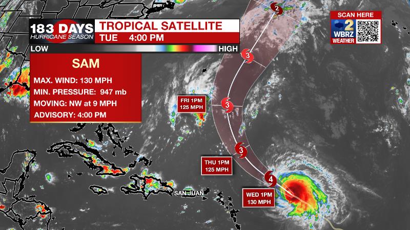
The Tropics: Hurricane Sam will pass well north of the Lesser Antilles this week before turning north into the Atlantic Ocean as a major storm by Friday. The remnants of Peter east of Bermuda have a 40 percent chance of regeneration before the middle of the week. A broad area of low pressure southwest of the Cabo Verde Islands has an 80 percent chance of formation while moving westward over the tropical Atlantic. A trailing wave rolling off the African Coast has a 90 percent chance of development over the next five days. For the latest tropical forecasts, advisories and information, visit the WBRZ Hurricane Center as we navigate all 183 Days of Hurricane Season.
Trending News
The Explanation: The axis of an upper level trough dug in across the Western U.S. will remain proximal to the area on Wednesday. With low level moisture in place, there should also be plenty of forcing to initiate showers and thunderstorms. Instability will be supportive of thunderstorms capable of brief downpours and 30mph wind gusts but upper level winds are not favorable for severe weather. An upper level disturbance will race over the area Wednesday afternoon and evening with the next scattered to widespread batch of showers and thunderstorms. Like all of the preceding activity, it should not produce more than brief downpours and perhaps gusty wind. As a whole, rainfall totals do not look impressive and so some standing water in low lying areas seems to be the most that is possible. The upper level trough will begin to lift north and flatten as an upper level ridge takes hold of the Eastern U.S. into the upcoming weekend. Enough moisture and instability will likely remain for scattered, afternoon showers and thunderstorms Thursday. By Friday, the ridge will warm the atmosphere to decrease instability and therefore cut into the number of showers and thunderstorms that can develop. Another, weaker upper level trough will cut across the southern half of the country Saturday and Sunday. As the center of this trough moves north of the area, there will be a period of increased chances for showers and thunderstorms—most likely late Saturday into Sunday. Atmospheric moisture will remain high enough that with seasonably warm temperatures, there will be instability present for at least isolated, afternoon showers and thunderstorms into early next week.
--Josh
The WBRZ Weather Team is here for you, on every platform. Your weather updates can be found on News 2, wbrz.com, and the WBRZ WX App on your Apple or Android device. Follow WBRZ Weather on Facebook and Twitter for even more weather updates while you are on the go.
More News
