

Latest Weather Blog
Tuesday AM Forecast: Cold front on the way to start off the fall season
Temperatures are set to take a dip.
THE FORECAST
Today & Tonight: The humidity will be very high today with partly cloudy skies and temperatures scratching 90 degrees. This evening, showers and storms will move in from the northwest along a cold front. Showers will enter the viewing area around 8 p.m. and reach the Baton Rouge area a bit later. Most of the shower activity will be overnight and will clear up before sunrise. Temperatures tonight will drop into the 60s behind the rain.
Up Next: Wednesday will bring cooler and drier air with afternoon temperatures struggling to reach the 80s and overnight lows dipping into the 50s. Thursday and Friday will be near repeats with afternoon temperatures around 80 degrees and clear skies. Overnight lows will trend in the mid-50s. The cool dry conditions will last through the weekend as temperatures slowly rebound. Early next week temperatures will warm up a bit into the mid-80s. Scattered showers will likely return in the middle of next week. Click here to see the 7-day forecast.
In the Tropics:
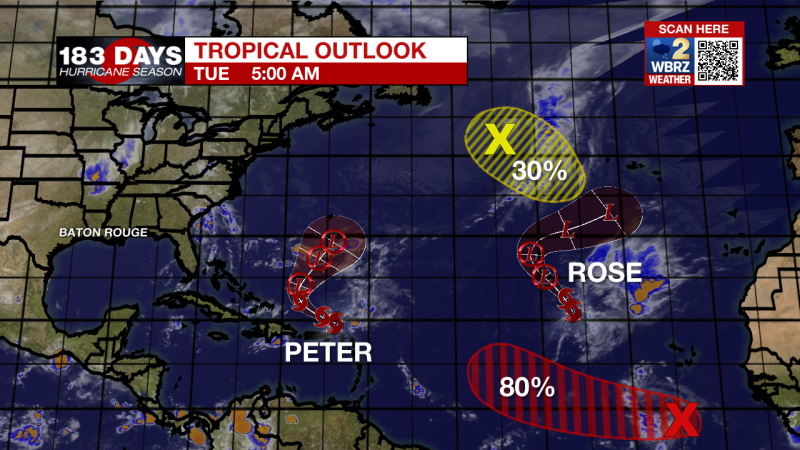
Tropical storms Peter and Rose are moving around in the Atlantic. Neither storm is a threat to the local area.
Trending News
Showers and thunderstorms associated with a tropical wave located a few hundred miles south-southwest of the Cabo Verde Islands continue to show some signs of organization. Environmental conditions are expected to become more conducive for development, and a tropical depression is likely to form later this week while the system moves westward at 10 to 15 mph across the eastern and central tropical Atlantic Ocean. There is an 80% chance of development in the next 5 days.
A storm-force, non-tropical low-pressure system, the remnants of Odette, is located several hundred miles southeast of Newfoundland. This low could acquire some subtropical characteristics during the next few days while it moves slowly southeastward over warmer waters across the north-central Atlantic Ocean. However, the system is expected to turn northward back over cooler waters this weekend, which should end its chances of becoming a subtropical storm. Additional information on this system, including storm warnings, can be found in High Seas Forecasts issued by the National Weather Service. There is a 30% chance of development in the next 5 days.
The WBRZ Weather Team is watching the tropics around the clock and will bring you updates as they come. Click here to visit the Hurricane Center.
Need weather conditions HOUR BY HOUR? Get hour by hour weather and right now weather conditions for your location on the WBRZ WX App on your Apple or Android device. Follow WBRZ Weather on Facebook and Twitter for even more weather updates and unique weather insight from the whole team!
More News
