

Latest Weather Blog
Thursday AM Forecast: More windy conditions expected for the Capital Area, no warnings or advisories issued for today
Another windy day but no current Red Flag warnings or wind advisories expected today.
THE FORECAST
Today & Tonight: Another cool start to the day with temperatures in the low-50s this morning. If you are enjoying the cooler weather, you’ll be happy to know its sticking around for a while. Today temperatures will struggle to break 80° across the area. No active warnings or advisories today, but we are still expecting windy conditions and gust up to 20mph. Skies will stay completely clear today and rain is not something we have to worry about in the forecast. Overnight temperatures will fall back into the mid-50s.
Up Next: Friday will be a near repeat of today, waking up with temperatures in the mid-50s and completely clear skies. As the day goes on, temperatures will top out in the low-80s with plenty of sunshine. Winds out of the northeast will be breezy at 5-10 mph with gust up to 20mph. Not expected and warnings or advisories for wind tomorrow. Into the overnight hours temperatures will fall back into the 50s. The cooler pattern is set on repeat for the weekend. Saturday and Sunday will have clear skies and plenty of sunshine. Day time highs will be a little warmer than what we have seen this past week in the mid-80s. Drier cooler conditions will keep us feeling like fall well into next week.
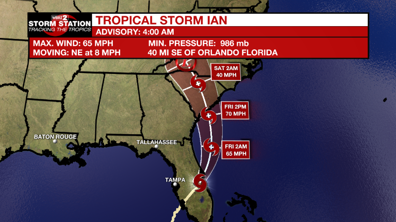
Tropics:
Trending News
Catastrophic Hurricane Ian made landfall near Cayo Costa, Florida around 3:05pm ET on Wednesday afternoon with maximum sustained winds of 155mph and a minimum central pressure of 940mb. Now a Tropical Storm, Ian will continue moving northeast at 8mph through today while gradually weakening due to land interactions. Still, devastating coastal impacts due to surge, torrential rain and battering wind will continue across western and central Florida. Ian will move over the western Atlantic Ocean by Thursday night making a second landfall as a tropical storm or hurricane near the Georgia or South Carolina coasts on Friday. For additional information on the ongoing impacts from Hurricane Ian, visit the National Hurricane Center website.
More News
