

Latest Weather Blog
This morning the first 40s, looking ahead to more of these
The Baton Rouge area is set to enjoy a long, pleasant stretch of fall weather that sets up beautifully for trick-or-treating and will carry through Election Day. The highlights include no rain and this fall’s first shot at readings in the 30s.
The Next 24 Hours: After hitting the 40s for the first time this fall season on Thursday morning, a repeat will be offered up into Friday. With northwest winds of 5-10mph, temperatures will stop around 46 degrees beneath mostly clear skies. The workweek will conclude with full sunshine, light north winds and high temperatures near 69 degrees.
After That: You could not really ask for much better fall weather this Halloween weekend. After another start in the 40s, high temperatures will break into the low 70s on a sunny Saturday afternoon. Candy collection should go one with some layers as thermometers slip into the low 60s after dusk. Ahead of a weak, reinforcing front, a few clouds may be stirred up through Sunday afternoon. Behind that boundary, an even cooler air mass will settle over the region with highs in the mid 60s on Monday followed by lows in the low 40s and possibly upper 30s Monday night. Gradual warming will follow to end the week. CLICK HERE to view your complete 7-Day Forecast.
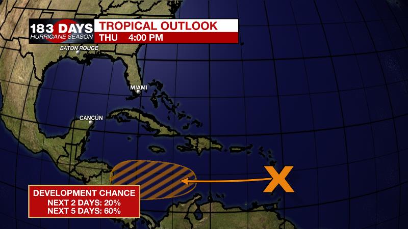
The Tropics: A tropical wave has been producing disturbed weather near the Lesser Antilles. Upper winds are expected to become more favorable and there is a 60 percent chance that a tropical depression forms over the next few days while the system moves westward across the Caribbean Sea.
Trending News
The Explanation: Very quiet weather (finally) will ensue over the coming week. The main forecast challenge with be with regard to low temperatures and even with that, there are few discrepancies. High pressure across the Ohio Valley will maintain northeast to easterly winds through Saturday keeping below average temperatures and clear conditions. An upper level trough will pass north of the region on Sunday morning, driving an associated cold front through the area. There will not be much moisture in the atmosphere and therefore very few clouds will develop along the front, let alone any rain. After briefly returning to the 70s and 50s, highs and lows will fall back into the 60s and 40s Monday into Tuesday. In fact, a lot of model guidance has low temperatures in the low 40s on the morning of Election Day. If winds lighten and decouple from the low levels of the atmosphere, some locations north of I-12 could nip the upper 30s for the first time this season. After that, a slight ridge in the upper levels will allow warming through the end of next week.
--Josh
The WBRZ Weather Team is here for you, on every platform. Your weather updates can be found on News 2, wbrz.com, and the WBRZ WX App on your Apple or Android device. Follow WBRZ Weather on Facebook and Twitter for even more weather updates while you are on the go.
More News
