Sunday PM Forecast: Dry, comfortable, and warm to start the workweek
Low humidity arrived on Sunday, and it will stick around into next week. Although the air will have a more comfortable feel, rain chances will be hard to come by as a result.
Tonight & Tomorrow: The lower humidity remains on Sunday night. We’ll see clear skies overnight and into Monday morning, with a low temperature reaching the middle-60s. Since July 1st, we’ve only had two mornings at Baton Rouge Metro Airport where temperatures dipped the 60s. This is a sign that Fall is getting closer! We’ll keep the low humidity on Monday, but it’ll still be warm. We’re forecasting a high temperature in the low to mid-90s under mainly sunny skies. At times, you may notice a high cloud or two.
Up Next: The extended forecast is uneventful. High temperatures won’t budge from day to day. We’re looking at highs in the low to mid-90s for the next week or so. Lows will be in the mid to upper-60s, with a few mornings struggling to get below 70°. From a humidity standpoint, it’ll be very comfortable on Monday and Tuesday. The humidity begins to creep upward by late week but should still be at tolerable levels. Without a ton of humidity and no major systems passing through, the forecast also looks completely dry for the workweek.
Get the latest 7-day forecast and real time weather updates HERE.
Watch live news HERE.
Trending News
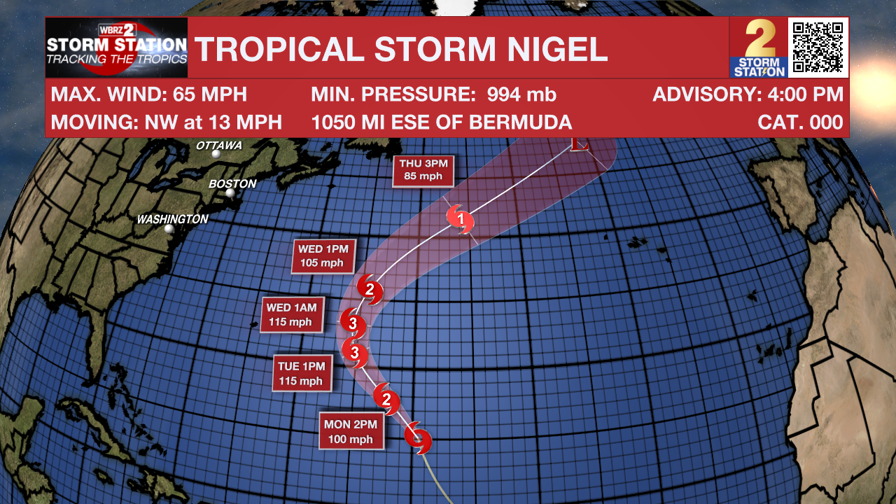
Tropics: The main system in the Atlantic Basin is no longer Lee, but now Nigel. Nigel remains a tropical storm as of Sunday afternoon, but is quickly intensifying. By Tuesday morning, the storm is forecast to become a major hurricane. Fortunately, Nigel will very likely go on the books as a “fish storm,” posing no threat to land.

After making landfall in Nova Scotia on Saturday, Lee continues to weaken as it pulls to the northeast. Lee is now a post-tropical system, meaning that it is losing its tropical characteristics.
Margot has also joined Lee as a post-tropical cyclone. This storm will continue to weaken into next week as the remnant energy slides south of the Azores.
-- Meteorologist Malcolm Byron
The Storm Station is here for you, on every platform. Your weather updates can be found on News 2, wbrz.com, and the WBRZ WX App on your Apple or Android device. Follow WBRZ Weather on Facebook and Twitter for even more weather updates while you are on the go.


