

Latest Weather Blog
Sunday Evening Forecast: steam continues, few more showers this week
While achieving official advisory criteria has been a challenge over the last few days, it is important to be aware of the recent ramp up in heat—our first taste this summer season. Cool down showers and thunderstorms will be the secondary story.
Next 24 Hours: Unfortunately, in these warm spells, nights don’t offer much relief. Beneath partly cloudy skies, thermometers will remain in the mid to upper 70s. Monday will be another steamy one with partly sunny skies driving high temperatures into the low to mid 90s. From late morning through late afternoons, feels-like temperatures will be over 100 degrees due to ample humidity. A few showers and thunderstorms will pop in the afternoon, with about 40 percent of the viewing area benefiting from a cooling shower.
Up Next: Tuesday may feature a bit less areal coverage in showers and thunderstorms. Otherwise, the same heat and humidity will press on. Wednesday through Friday, a weak upper level disturbance crossing the Gulf of Mexico from east to west will slightly increase the coverage of showers and thunderstorms but this will be a nuanced aspect of the forecast. After all, in mid-summer, the weather is pretty consistent in south Louisiana and southwest Mississippi. CLICK HERE for your full 7-Day Forecast.
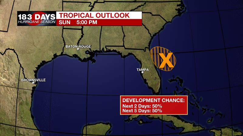
The Tropics: A well-defined low pressure area located about 160 miles east of Daytona Beach, Florida, continues to produce disorganized shower and thunderstorm activity mainly to the east and southeast of the center. Environmental conditions are expected to be marginally conducive for development, and there is a 50 percent chance that a tropical depression could still form later today or early Monday while the system drifts westward toward the east coast of Florida. For the latest tropical forecasts and information, visit the WBRZ Hurricane Center as we navigate all 183 Days of Hurricane Season.
Trending News
The Explanation: Due to some slightly drier upper level air across the southeastern half of the forecast area, there will likely be a bit of a cutoff as to where the best chances for afternoon showers and thunderstorms will occur on Monday. At this time, locations north and west of Baton Rouge are more likely to see some action while areas south and east, closer to New Orleans, have a better chance of missing rain. For all, heat and humidity will continue as was the case over the weekend. On Tuesday, moisture will fill in across the area with standard 30 to 50 percent coverage in showers and thunderstorms expected. An upper level trough digging into the Mid-Atlantic region will send a weak cold front from northeast to southwest into the central Gulf Coast region during the second half of the week before dissipating well north of the area on Saturday. As Gulf moisture pools south of the triggering front, upper level winds will be northerly. Therefore, showers and thunderstorms are expected to develop near the boundary and drift southward into the area, colliding with marine breezes for scattered to widespread activity each afternoon Wednesday through Friday. Those northerly winds will also put some drier air into the mid to upper levels of the atmosphere, which can be supportive of gusty wind in stronger thunderstorms. So, be aware of that threat in addition to downpours and frequent lightning. The good news is, the added coverage in showers and thunderstorms should help to tame the long duration 100 degree-plus feels-like temperatures for a few days, But it is still summer and it will still be plenty hot and humid until any showers get going each day. The shower and storm count should go down next weekend, pushing heat up again.
--Josh
The WBRZ Weather Team is here for you, on every platform. Your weather updates can be found on News 2, wbrz.com, and the WBRZ WX App on your Apple or Android device. Follow WBRZ Weather on Facebook and Twitter for even more weather updates while you are on the go.
More News
