

Latest Weather Blog
Sunday AM Forecast: Less rain today but some will still see showers
Foggy start for today, some afternoon showers possible.
THE FORECAST
Today & Tonight: A hot and humid start for today. Some areas waking up to foggy conditions, the fog will begin to lift as the sun continues to rise. Throughout the day today temperatures will have plenty of time to heat into the mid-to-upper 80s across the area. Some cloud cover will move in, but the skies will stay mostly sunny long enough to really heat us up. Isolated showers are possible mainly during the afternoon hours. Not everyone will see rain, and if you do do not worry it will be brief. Southerly winds have set into the forecast pumping more moisture into our area. Overnight the pattern repeats, cloud cover sticks around into the evening hours and we will wake up muggy for Monday.
Up Next: Monday will bring more of the same hot and humid pattern for the start of your work week. Fog is possible to start your day again on Monday. It will be a near repeat of Sunday just without the chance for some showers to bubble up. Afternoon temperatures will get into the upper-80s. It will be feeling hot and humid throughout the day and overnight things will cool down some but not enough. An upper level high pressure sets into the area throughout the workweek. The warm and humid pattern will not be going anywhere anytime soon. Click here to see the 7-day forecast.
The Storm Station has you covered with hour-by-hour weather tracking is available for your location on the WBRZ WX App on your Apple or Android device. Follow WBRZ Weather on Facebook and Twitter for even more weather updates and unique weather insight from the whole team!
In the Tropics:
Trending News
There are two disturbances in the Atlantic that are not a threat to the local area.
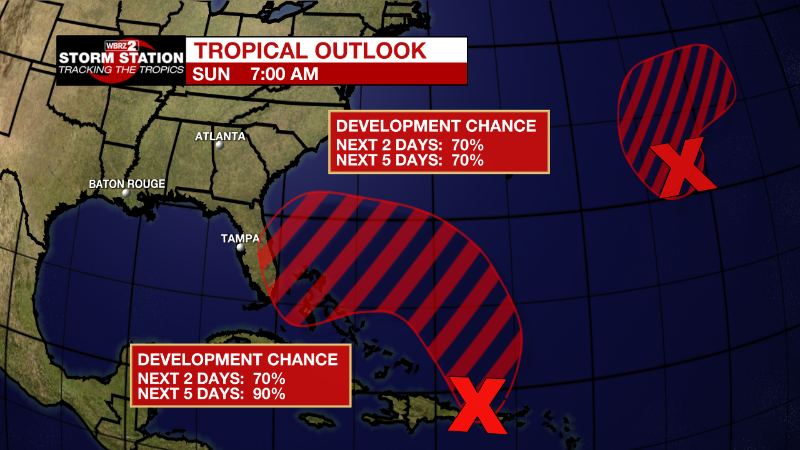
Central Subtropical Atlantic:
A well-defined low pressure area located several hundred miles east
of Bermuda is associated with an area of showers and thunderstorms.
This activity has been attempting to redevelop closer to the center,
and if these trends continue, a short-lived tropical depression or
storm is likely to form later today while the system drifts slowly
over the central Atlantic. Thereafter, the system is forecast to
turn northeastward and merge with a strong cold front by the middle
part of this week. Additional information on this system, including
gale warnings, can be found in High Seas Forecasts issued by the
National Weather Service.
* Formation chance through 48 hours...high...70 percent.
* Formation chance through 5 days...high...70 percent.
Southwestern Atlantic:
An area of low pressure is developing about 100 miles north of
Puerto Rico and is producing a large area of disorganized showers
and thunderstorms. This system is forecast to move northward or
northwestward further into the southwestern Atlantic today and
environmental conditions appear generally conducive for additional
development. A subtropical or tropical depression is likely to form
early this week while the system turns westward or
west-southwestward over the southwestern Atlantic. Regardless of
development, there is an increasing risk of coastal flooding,
gale-force winds, heavy rainfall, rough surf, and beach erosion
along much of the southeastern United States coast, the Florida east
coast, and portions of the central and northwestern Bahamas during
the early to middle part of this week. Interests in those areas
should continue to monitor the progress of this system.
* Formation chance through 48 hours...high...70 percent.
* Formation chance through 5 days...high...90 percent.
More News
