

Latest Weather Blog
Severe weather risk for New Year's Eve
Tracking a severe weather risk for New Year’s Eve.
THE FORECAST
Today and Tonight: Today will be very similar to yesterday, but instead of watching the clouds thin out, we will see them build in. Even though it will be cloudy, rain chances will be very low. A few coastal showers are possible. Temperatures will be near 70 this afternoon, and with building clouds, overnight temperatures will be near 60 degrees.
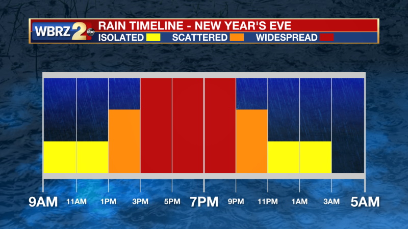
Up Next: Wednesday will start out muggy and rainy in the morning with scattered showers and storms in the afternoon mainly north and west of Baton Rouge. The major rainmaker will move in on Thursday. A cold front will approach the area on Thursday afternoon with storms moving in ahead of it.
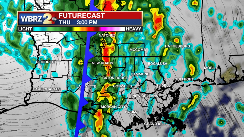
The WBRZ viewing area is under a SLIGHT (2/5) risk for severe weather on Thursday associated with this line of storms. This means any storms that move through will be capable of producing damaging straight-line winds as well as a tornado or two. Stay with the WBRZ Weather Team this week as we continue to update the forecast and timeline on this potential severe event.
Trending News
After those storms move out on Thursday, much cooler, drier air will move in behind them. The new year will start with temperatures in the 50s. Cool and dry conditions will stick around for the weekend too. Click here to see the 7-day forecast.
Get right now weather conditions for your location on the WBRZ WX App on your Apple or Android device. Follow WBRZ Weather on Facebook and Twitter for even more weather updates and unique weather insight from the whole team!
More News
