

Latest Weather Blog
Saturday AM Forecast: Tornado Watch for portions of the WBRZ viewing area Expired
Stay connected with the Storm Station so that you can be prepared.
The National Weather Service has issued a TORNADO WATCH for Livingston, St.Helena, Tangipahoa parishes and Amite county. The watch will expire at 3:00pm. The system of interest is continuing to move to the east. A tornado watch means conditions are favorable for tornadoes, isolated hail up to a half inch, isolated wind gust up to 70 mph. EXPIRED
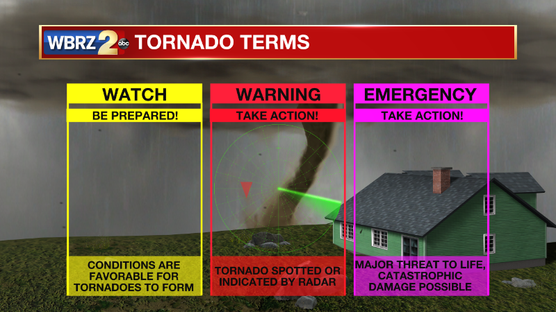
We are currently in a tornado WATCH. This means conditions are favorable, but you should have a plan in place.
THE FORECAST
Trending News
Today & Tonight: The Storm Station is watching a frontal system that will bring impactful weather to the viewing area early this morning. Southerly winds are pumping in moisture and instability into our atmosphere. This means as we start to see shower development some of the showers could quickly intensify and turn into strong thunderstorms. Our main risk are for gusty winds, heavy downpours, and the possibility of an isolated tornado. The threat will be primarily in the morning hours for the viewing area. If you have outdoor plans from 8AM to 1PM, I suggest making an indoor back up plan. The severe weather threat has shift to the east. At this point it looks like showers and storms will not be fully developed until they track past Baton Rouge.
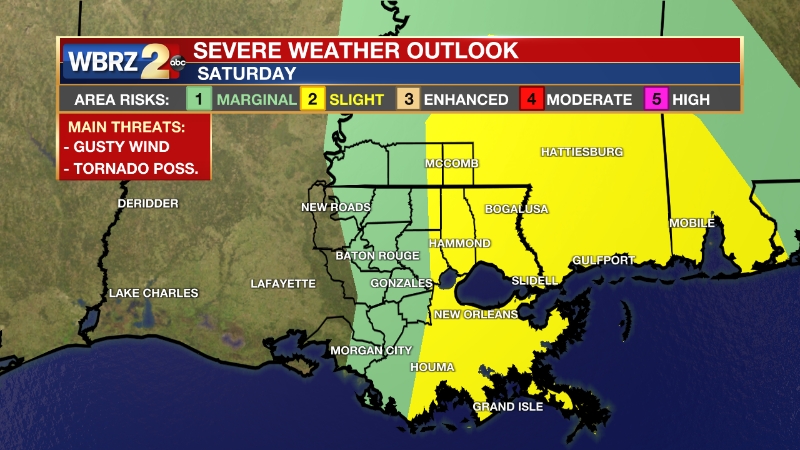
You will see a line of showers and storms and then some clearing out. By the afternoon hours you can expect all shower and storm activity to be out of the WBRZ viewing area. Initially we will see mostly sunny skies, the break in cloud cover will allow daytime highs to creep into the mid-70s. Before the day is over cloud cover will return to the forecast and overnight lows will drop into the mid-50s.
Up Next: Sunday will bring cooler temperatures back into the forecast. You will be waking up in the mid-50s, cloud cover will lock in the humidity. Into the afternoon hours temperatures will struggle to get into the low-70s. Still feeling humid, but the chance for rain is unlikely on Sunday due to the lack of daytime heating. Overnight things cool back down and we repeat the same pattern for Halloween. No spooks or scares in this Halloween forecast. We will be sitting seasonable with daytime highs in the low-70s. Trick-or-Treaters will not be interrupted by the weather. Our next rain maker will come in on Tuesday night. Click here to see the 7-day forecast.
A risk for severe weather, be sure you have a way of staying connected. The Storm Station has you covered with hour-by-hour weather tracking is available for your location on the WBRZ WX App on your Apple or Android device. Follow WBRZ Weather on Facebook and Twitter for even more weather updates and unique weather insight from the whole team!
In the Tropics:
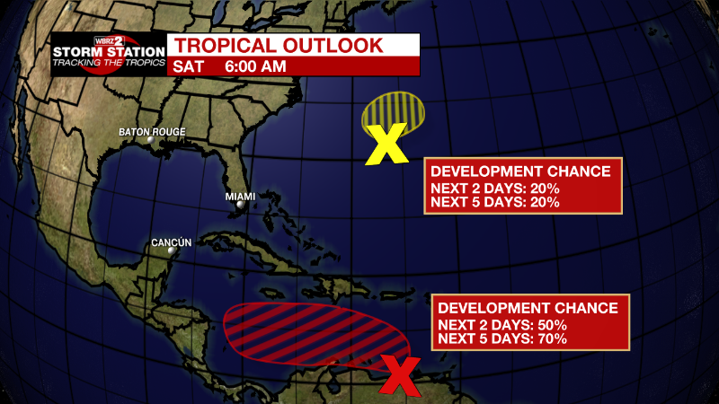
The National Hurricane Center is monitoring a pair of disturbances. While the area in the Caribbean may grab your attention, it is very unlikely that any development interacts with the United States. Strong cold fronts will continue to divert tropical activity away from the Gulf of Mexico.
Eastern Caribbean:
A broad area of low pressure over the eastern Caribbean Sea is
producing a large area of disorganized showers and thunderstorms.
Environmental conditions are forecast to be conducive for gradual
development over the next few days, and a tropical depression is
likely to form by early next week while the disturbance moves slowly
westward or west-northwestward over the central Caribbean Sea.
Regardless of development, locally heavy rainfall is possible over
portions of the Lesser Antilles, the Virgin Islands, and Puerto Rico
through this weekend.
* Formation chance through 48 hours...medium...50 percent.
* Formation chance through 5 days...high...70 percent.
Western Atlantic:
A low pressure area located about 150 miles west-northwest of
Bermuda is producing some shower and thunderstorm activity to the
north of the center as it begins to interact with a nearby frontal
system. Upper-level winds are forecast to increase over the system
later today and tonight, and further development is not anticipated
after that time.
* Formation chance through 48 hours...low...20 percent.
* Formation chance through 5 days...low...20 percent.
More News
