

Latest Weather Blog
Saturday AM Forecast: Tailgate forecast is here and skies will remain mostly clear
Tailgate forecast is here and it is looking like the PERFECT day for some LSU football
THE FORECAST
Today & Tonight: Another sunny start today with temperatures in the high-60s across the Capital Area. More sunshine headed your way for your game day forecast. Tailgaters can expect temperatures to gradually rise to just over 90° throughout the afternoon hours. Some cloud cover will begin to build into the area, but for the better part of the day you will be seeing sunny skies. Coastal showers are possible as winds start to turn out of the southeast. Areas further inland have a better chance of staying completely dry this weekend. Some humidity will begin creeping into the forecast, not to worry, it will not be sticking around for very long. Overnight expecting more cool comfortable conditions with temperatures falling into the 70s.
Up Next: Sunday will be more of the same. Waking up to mostly sunny skies and winds out of the southeast. The wind shift out of the southeast will bring in more moisture into the forecast. Still not tracking a total washout for Sunday but more showers are likely. As temperatures heat up into the 90s shower and storm activity will become more likely. Most of the rain will stay to the south along the coastline, but I would not rule out a shower or two bubbling up north of the I-10 corridor. Into the evening the little shower activity will settle down as the sun begins to set. Overnight temperatures will settle back into the 70s. For the start of your workweek, expect more heat and less humidity in the forecast. Starting your day temperatures will be in the 70s, gradually rising into the low-90s throughout the day. Rain chances stay on the lower side for most of the week and humidity stays a little lower. Not quite fall yet… but drier conditions are expected for your workweek. Click here to see the 7-day forecast.
Need a game day forecast? The Storm Station has you covered with hour-by-hour weather tracking is available for your location on the WBRZ WX App on your Apple or Android device. Follow WBRZ Weather on Facebook and Twitter for even more weather updates and unique weather insight from the whole team!
Trending News
In the Tropics:
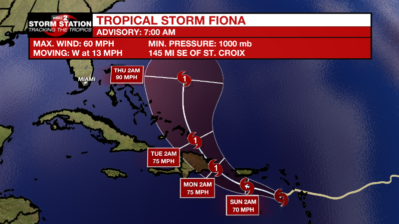
As of 8 am Saturday, Tropical Storm Fiona was crossing over the Leeward Islands with maximum sustained winds of 60mph. Moving west at 13mph, Fiona will continue on this track but slow down over the weekend before turning west-northwest early next week. Some gradual strengthening is possible. Storm force winds and heavy rain are expected across the Leeward Islands, Virgin Islands, Puerto Rico and Hispaniola. The highest elevations of Puerto Rico could pick up about ten inches causing serious flooding.
Central Atlantic:
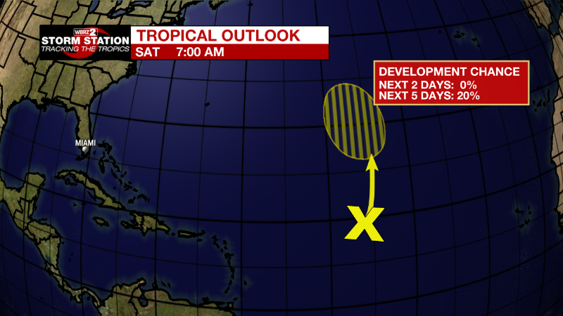
Disorganized showers and thunderstorms over the central Atlantic are
associated with the northern portion of a tropical wave. Some slow
development of this system is possible during the early or middle
part of next week while it moves slowly northwestward to northward.
* Formation chance through 48 hours...low...near 0 percent.
* Formation chance through 5 days...low...20 percent.
More News
