

Latest Weather Blog
Saturday AM Forecast: Nice football weather, more of the same for tomorrow
Today will be comfortable, more moisture moves in over the weekend.
THE FORECAST
Today & Tonight: Waking up this Saturday to nothing but sunny skies. Humidity is low and temperatures are also starting on the cooler side in the mid-50s. Throughout the day temperatures are going to get on the warm side, with daytime highs topping out in the low-80s. Both LSU and Southern have their homecoming games today and the weather is going to be perfect. There will be a light southerly breeze with dew points holding in the 50s leaving us feeling comfortable throughout the day. Into the evening hours any clouds will clear out and temperatures will drop back into the 60s.
Up Next: Sunday will be a near repeat but expect more moisture to start moving into the area. Waking up you will see some clouds in the skies to start your day and temperatures will be in the low-60s. More cloud cover is expected to build in as southerly winds continue pumping more moisture into the area throughout the day. Daytime highs will be in the mid-80s but feeling closer to the high-80s with the added humidity. Into the evening hours clouds and humidity stick around and overnight lows will struggle to fall back into the mid-60s. Gradually we will see a warming trend in the forecast. Monday will be on the warm side with more cloud cover. Tuesday will be hot and humid as showers begin creeping in. The timing of the cold front will be key. If the front moves through earlier in the day on Tuesday we will see more scattered showers, however if the front stalls out we have a chance of seeing some thunderstorms along this front as it passes through the Capital Area. Once the front pushes through we will be back feeling more like fall again. Click here to see the 7-day forecast.
Quick cold front moving through, do not let sneaky showers catch you off guard. The Storm Station has you covered with hour-by-hour weather tracking is available for your location on the WBRZ WX App on your Apple or Android device. Follow WBRZ Weather on Facebook and Twitter for even more weather updates and unique weather insight from the whole team!
In the Tropics:
Trending News
The area of potential development will not impact the local viewing area if it does develop.
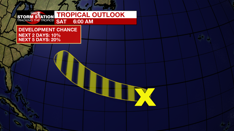
Central Subtropical Atlantic:
A small, non-tropical area of low pressure located well east of
Bermuda is producing limited shower activity. Although environmental
conditions are only marginally conducive for development during the
next few days, the low could still acquire some subtropical or
tropical characteristics by early next week while it moves westward
to west-northwestward at 15 to 20 mph across the subtropical
Atlantic. By the middle part of next week, further development
appears unlikely while the system moves northwestward over cooler
waters of the northwestern Atlantic and encounters stronger
upper-level winds. Additional information on this system, including
gale warnings, can be found in High Seas Forecasts issued by the
National Weather Service.
* Formation chance through 48 hours...low...10 percent.
* Formation chance through 5 days...low...20 percent.
More News
