

Latest Weather Blog
Saturday AM Forecast: Another great weekend for football in the Capital City
More sunshine and comfortable weather for the weekend forecast.
THE FORECAST
Today & Tonight: Chilly start for the Capital Area this morning. Fall has really set into the forecast this past week. Clear skies and sunshine expected all weekend long. Breezy conditions will stick around the forecast making it a little chilly at the start of the day, but by the afternoon hours windy conditions are enjoyable. Temperatures this afternoon will top out in the low-80s. If you are heading to the Southern game this weekends tailgate forecast is looking perfect. Comfortable conditions at the tailgate, then in the upper-70s at the start of the game, then temperatures dropping to the low-70s by the time you are heading home. Overnight things will cool back down into the mid-50s and the pattern is set to repeat for Sunday.
Up Next: Sunday will be another beautiful day across the area. Temperatures waking up in the 50s with a slight wind out of the northeast. Throughout the day temperatures will warm into the low-80s but plenty of sunshine and not a cloud in the sky. Overnight temperatures will cool back down. Northeasterly winds are going to continue to pump cooler drier area into the Capital Area. The upper-level system is not expected to change anytime soon locking us in this fall pattern, the complaint department is closed. Temperatures are expected to gradually rise as we go throughout the workweek with daytime highs topping out in the mid-80s. Even as temperatures heat up a bit, dew points will stay on the lower side leaving us with comfortable conditions. Completely clear skies expected all week long.
The Storm Station is here for you, on every platform. Your weather updates can be found on News 2, wbrz.com, and the WBRZ WX App on your Apple or Android device. Follow WBRZ Weather on Facebook and Twitter for even more weather updates while you are on the go.
In the Tropics:
Hurricane Ian made a second landfall around 2:05 ET near Georgetown, South Carolina with maximum sustained winds of 85mph. Rapid weakening happening as Ian continues to stay over land. Still a tropical low with some rain and winds associated with this system. Expected to fizzle out late this afternoon.
Trending News
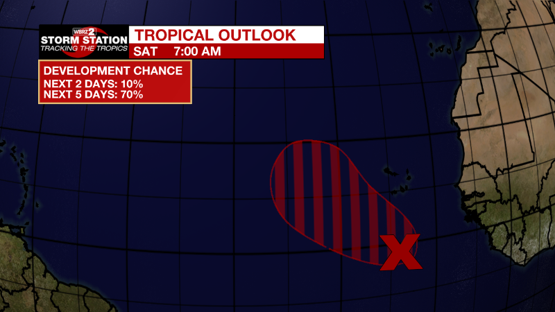
Eastern Tropical Atlantic:
A tropical wave is producing disorganized showers and thunderstorms
several hundred miles south of the Cabo Verde Islands.
Environmental conditions are forecast to be conducive for gradual
development of this system, and a tropical depression is likely to
form during the early to middle part of next week while it moves
westward and then northwestward at 5 to 10 mph over the eastern
tropical Atlantic.
* Formation chance through 48 hours...low...20 percent.
* Formation chance through 5 days...high...70 percent.
More News
