

Latest Weather Blog
Monday PM Forecast: warmth continues but a cold front is in sight
Going back to last Thursday, a possible 8 of 10 record high and record high low temperatures were broken. Warmth will continue for the majority of the week.
Tonight & Tomorrow: A weak cold front will move through the area overnight but will struggle to do more than maintain mostly cloudy skies. A stray shower is possible farther south and east of Baton Rouge. As winds shift westerly behind the front, some drier air will guide low temperatures into the mid 60s. Tuesday will be unseasonably warm again with high temperatures in the low 80s. However, west breezes of 5-10mph will result in a drier and more pleasant feel. Some clouds will linger early but more sun will become available through the day.
Up Next: Wednesday and Thursday will continue the warm pattern with highs in the 80s and lows in the upper 60s. Clouds will start to increase on Thursday ahead of the next cold front. A stray shower or thunderstorm will be possible late, but activity will increase overnight. A line of rain and thunderstorms is anticipated on Friday morning that will come with a chance of severe weather. On the other side of the front, skies will clear for the weekend with a three to four day stretch of near average temperatures. Expect highs in the upper 60s and low 70s and lows in the mid 40s.
Get the latest 7-day forecast and real time weather updates HERE.
Watch live news HERE.
Trending News
Detailed Forecast: With the warm weather causing upper level ridge of high pressure smashed a bit farther to the south, winds have turned westerly in parallel with a cold front settling across the region. The front has minimal moisture to use in the atmosphere and therefore showers and thunderstorms are unlikely. Once the front falls apart over or just east of the area, winds will shift to a west direction and allow some drier air to move into the region, by no significant cooling. Not much changes for the middle of the week. By Thursday, upper level winds will start to come out of the southwest, increasing moisture in the atmosphere. A deep upper level trough of low pressure will make a move from the Southwest U.S. into the Midwest causing a surface low to develop over Texas and race to the northeast. This low will bring a cold front across the central Gulf Coast Thursday night into Friday morning.
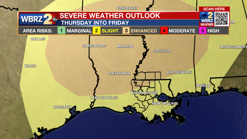
A squall line is anticipated along the boundary and move into a favorable environment for severe weather. The upper level winds will be very supportive overnight with plenty of wind shear and low level moisture as well. The one limiting factor may be the time of day and instability. However, the lift generated by the front alone will be enough to have at least a strong line of thunderstorms move through with potential for gusty wind and some hail. Especially if some development occurs ahead of the boundary, a tornado threat may develop as well. Behind the front, much cooler, drier and more seasonable air will arrive with lows in the 40s and highs in the 70s for the weekend.
--Josh
The Storm Station is here for you, on every platform. Your weather updates can be found on News 2, wbrz.com, and the WBRZ WX App on your Apple or Android device. Follow WBRZ Weather on Facebook and Twitter for even more weather updates while you are on the go.
More News
