

Latest Weather Blog
Monday PM Forecast: scattered storms continue, front arrives midweek
Scattered showers and thunderstorms remain in play. A weak front will slip into the area from the north later this week.
Next 24 Hours: As showers wane in coverage, some clearing is expected overnight. Low temperatures will bottom out in the mid 70s. High temperatures will climb into the low 90s on Tuesday in response to partly sunny skies, early. A few showers and thunderstorms will meander through the region in the afternoon.
Up Next: A front will drop in from the north on Wednesday. This will trigger showers and thunderstorms, especially during the afternoon and evening hours. Any of the storms will be capable of gusty wind. On the other side of the front, the atmosphere will dry a bit on Thursday providing a very brief period of fewer showers and thunderstorms. Tropical moisture will surge right back into the area on Friday and scattered to widespread showers and thunderstorms are anticipated both weekend days. The return of more rain and more clouds will limit high temperatures to the upper 80s, which is only three, or four degrees below average for early September. CLICK HERE for your detailed 7-Day Forecast.
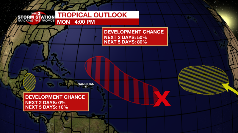
The Tropics: A broad area of low pressure over the central tropical Atlantic is producing a large area of disorganized cloudiness and showers. Although environmental conditions are only marginally conducive, there is an eighty percent chance of some gradual development of this system. A tropical depression is likely to form later this week as it moves slowly toward the west and then west-northwest at 5 to 10 mph.
Trending News
A small low pressure system located about 600 miles east of Bermuda continues to produce limited shower activity. Strong upper-level winds and dry air are expected to limit significant development of this system while it drifts southward and southwestward over the central Atlantic during the next couple of days.
A tropical wave is forecast to move off the west coast of Africa this evening or early Tuesday. There is a thirty percent chance of some gradual development of this system is possible after that time while it moves generally westward to west-northwestward across the far eastern tropical Atlantic.
A trough of low pressure could develop over the northwestern Caribbean Sea later this week. Environmental conditions could support a ten percent chance of slow development of the system thereafter while it moves generally west-northwestward over the northwestern Caribbean Sea and toward the Yucatan Peninsula.
The Explanation: The marine breezes will work with daytime warming to kick out a few showers and thunderstorms on Tuesday. By Wednesday, an upper level trough will send a surface front into the region, which will kick out scattered showers and thunderstorms. Since the upper trough will push some drier air into the atmosphere, any thunderstorms could contain gusty winds. That drier air aloft could reach as far south as I-10 Wednesday night into Thursday helping to keep lower end rain coverage north of the interstates. However, moisture will surge back into the area by Friday as a weak trough of low pressure moves from southeast to northwest across the Gulf of Mexico. These features will promote greater rain coverage once again for next weekend. By then, increased activity will likely keep high temperatures a few degrees below average, in the upper 80s.
--Josh
The Storm Station is here for you, on every platform. Your weather updates can be found on News 2, wbrz.com, and the WBRZ WX App on your Apple or Android device. Follow WBRZ Weather on Facebook and Twitter for even more weather updates while you are on the go.
More News
