

Latest Weather Blog
Friday PM Forecast: keeping warm, most dry for a while
Quiet but warm weather will be the story into next week. For most, the dry conditions will continue as well.
Next 24 Hours: Another night of mostly clear skies and comfortable temperatures is ahead. Thermometers will dip into the mid 60s. Saturday will be a repeat of the last few with mostly sunny skies and highs in the upper 80s.
Both the LSU and Southern football teams will compete on the road this weekend. The Jags will play in Houston at 4pm, kicking off to mostly sunny skies and temperatures in the mid 80s. The Tigers will start after dark in Kentucky with mostly clear skies and temperatures in the low 70s.
Up Next: Mostly sunny skies and mid to upper 80s are again on tap for Sunday. With a gradual wind change, some Gulf humidity may start to creep back into the area. Therefore, lows will bump up a degree or so each morning with upper 60s and low 70s expected for most of next week. Through Thursday, days will be mostly to partly sunny and with low, but not zero, rain chances. Even though highs are expected to top out in the upper 80s, an isolated reading of 90 is possible. This would not be terribly uncommon; while the average last 90-degree high comes on October 2, it has happened as late as October 26. A cold front could swing through the area late next week. While it looks pretty weak at this time, some slightly cooler air is possible and both major global forecast models hint at temperatures at or below average by next weekend. CLICK HERE for your full 7-Day Forecast.
Trending News
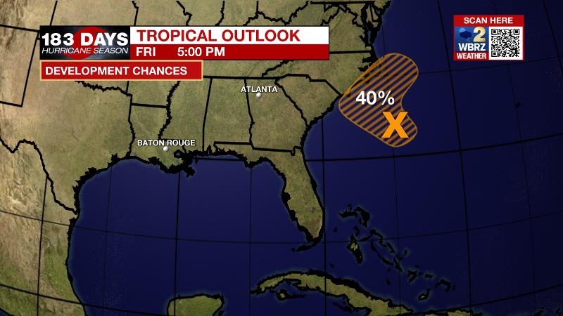
The Tropics: A low pressure area off the coast of South Carolina continues to produce disorganized showers and thunderstorms to the east of its center of circulation. There is a 40 percent chance of tropical or subtropical development through the weekend before the low interacts with a front. For the latest tropical forecasts, advisories and information, visit the WBRZ Hurricane Center as we navigate all 183 Days of Hurricane Season.
The Explanation: Quiet weather will persist through the weekend as an upper ridge builds into the region. This will cause sinking, warming air resulting in high temperatures remain slightly above normal and mostly clear skies. Going into Monday, an upper level trough moving into north Texas and its associated cold front will pass north of the area. Isolated showers may develop south of this feature, in our area, but no major impacts and certainly no frontal passage to change temperatures. A gradual shift to southeast winds early next will also return higher dew points/humidity and therefore low temperatures in the upper 60s and low 70s. By midweek, another upper level low and cold front will approach the region and begin Lifting northeast.
A trailing, weaker trough could provide just enough push to send the cold front into the local area around next weekend. So far out and with poor support shown in the upper levels from the forecast models, a worthwhile front with more fall like air is a lower end probability right now.
--Josh
The WBRZ Weather Team is here for you, on every platform. Your weather updates can be found on News 2, wbrz.com, and the WBRZ WX App on your Apple or Android device. Follow WBRZ Weather on Facebook and Twitter for even more weather updates while you are on the go.
More News
