

Latest Weather Blog
Friday PM Forecast: A risk of severe weather for the entire viewing area for Saturday morning
Severe weather threats starting early tomorrow morning, showers and storms will be gone by the afternoon.
THE FORECAST
Tonight & Tomorrow: The Storm Station is watching a frontal system that will bring impactful weather to the viewing area starting tonight. This evening we will start to see some spotty showers moving through. Overnight into Saturday morning, winds will shift out of the south and will bring more moisture into the viewing area. Starting your Saturday expect to see cloud cover then some showers first thing. A cold frontal boundary will be approaching Saturday morning, this is where we start to see a chance for severe weather. The Capital Area is under a Level 2/5 Slight risk for gusty winds and a tornado as this system passes. The timing is, you will wake up to cloudy conditions and some isolated showers. By 7 AM showers and storms will become more developed as the line moves further to the west. From 7AM to 1PM you should have a back up indoor plan. The storms will move from west to east throughout the area and gradually intensify. After lunch most of the viewing area will be in the clear, but we will still be left with cloudy conditions. Daytime highs will struggle to reach the mid-70s.
Up Next: Sunday will bring improving conditions to the forecast. Waking up with partly sunny skies and temperatures in the mid-60s. Throughout the day temperatures will stay seasonable topping out in the mid-to-low 70s. The cloud cover hangs around the forecast into your Halloween Monday. Trick-or-treaters will not be impacted by the weather. We are expecting a partly cloudy, muggie start followed by warming temperatures into the afternoon hours. By the time we get to trick-or-treating temperatures will be in the low-70s upper-60s. Click here to see the 7-day forecast.
A risk for severe weather, be sure you have a way of staying connected. The Storm Station has you covered with hour-by-hour weather tracking is available for your location on the WBRZ WX App on your Apple or Android device. Follow WBRZ Weather on Facebook and Twitter for even more weather updates and unique weather insight from the whole team!
In the Tropics:
Trending News
The National Hurricane Center is monitoring a pair of disturbances. While the area in the Caribbean may grab your attention, it is very unlikely that any development interacts with the United States. Strong cold fronts will continue to divert tropical activity away from the Gulf of Mexico.
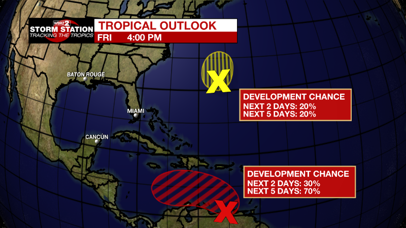
Eastern Caribbean:
A broad area of low pressure over the eastern Caribbean Sea
continues to produce a large area of disorganized showers and
thunderstorms extending from the Windward Islands west-northwestward
for several hundred miles. Environmental conditions are forecast to
be conducive for gradual development over the next few days, and a
tropical depression is likely to form this weekend or early next
week while the disturbance moves slowly westward or
west-northwestward over the central Caribbean Sea. Regardless of
development, locally heavy rainfall is possible over portions of the
Lesser Antilles, the Virgin Islands, and Puerto Rico through this
weekend.
* Formation chance through 48 hours...low...30 percent.
* Formation chance through 5 days...high...70 percent.
Western Atlantic:
Satellite data indicate that a well-defined low pressure area has
formed about 150 miles southwest of Bermuda. This system is
currently producing a limited amount of shower and thunderstorm
activity. Environmental conditions are forecast to remain only
marginally conducive, and any additional development should be slow
to occur over the next day or so. By late Saturday, upper-level
winds are forecast to become even less favorable, and the low is
expected to begin interacting with an approaching frontal system.
Therefore, development after that time is not anticipated.
* Formation chance through 48 hours...low...20 percent.
* Formation chance through 5 days...low...20 percent.
More News
