

Latest Weather Blog
Damage surveys confirm additional tornadoes from Monday, May 13th
On the heels of last week's severe weather, the National Weather Service (NWS) completed another round of damage surveys. The NWS has determined that three additional tornadoes touched down from storms on the night of Monday, May 13th, 2024. Two of those tornadoes tracked through portions of Iberville Parish, while third did damage in Livingston Parish. That brings the total count from May 13th to four, which includes previously confirmed tornado near Livonia.
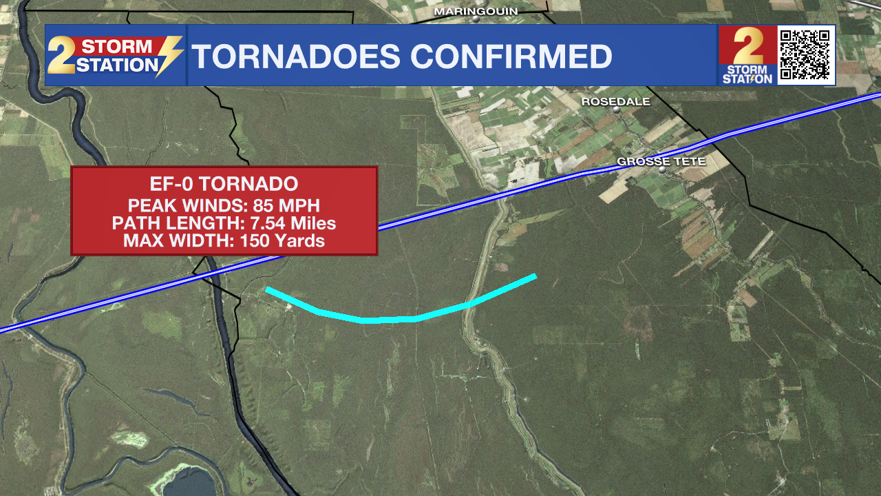
Tornado #1 - Iberville Parish:
An EF-0 tornado tracked south if I-10 primarily over rural parts of the Atchafalaya Basin. Peak winds were estimated at 85 mph. The tornado was on the ground from 6:39 p.m. to 6:47 p.m., tracking 7.54 miles. Satellite analysis showed a "scalloped swath of tree damage associated with a strong circulation." Ground surveys also noted uprooted trees and large branches as the tornado crossed Atchafalaya Basin Levee Road. This was the only accessible road to survey damage.
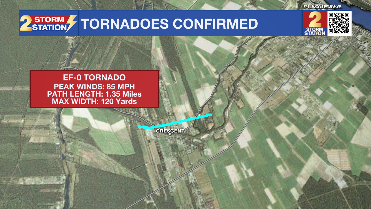
Tornado #2 - Iberville Parish:
Another EF-0 tornado impacted portions of Crescent, LA, with peak estimated winds at 85 mph. The tornado was on the ground from 6:54 p.m. to 6:56 p.m. with a path length of 1.35 miles. The tornado first touched down near Guilotta Lane where it primarily damaged trees along Bayou Road. A few homes sustained damage to their roofs as it continued to track north of Crescent Elementary School. The tornado continued east where numerous trees were uprooted just to the north of Bayou Jacob Road near Dozier Road before lifting shortly after.
Trending News
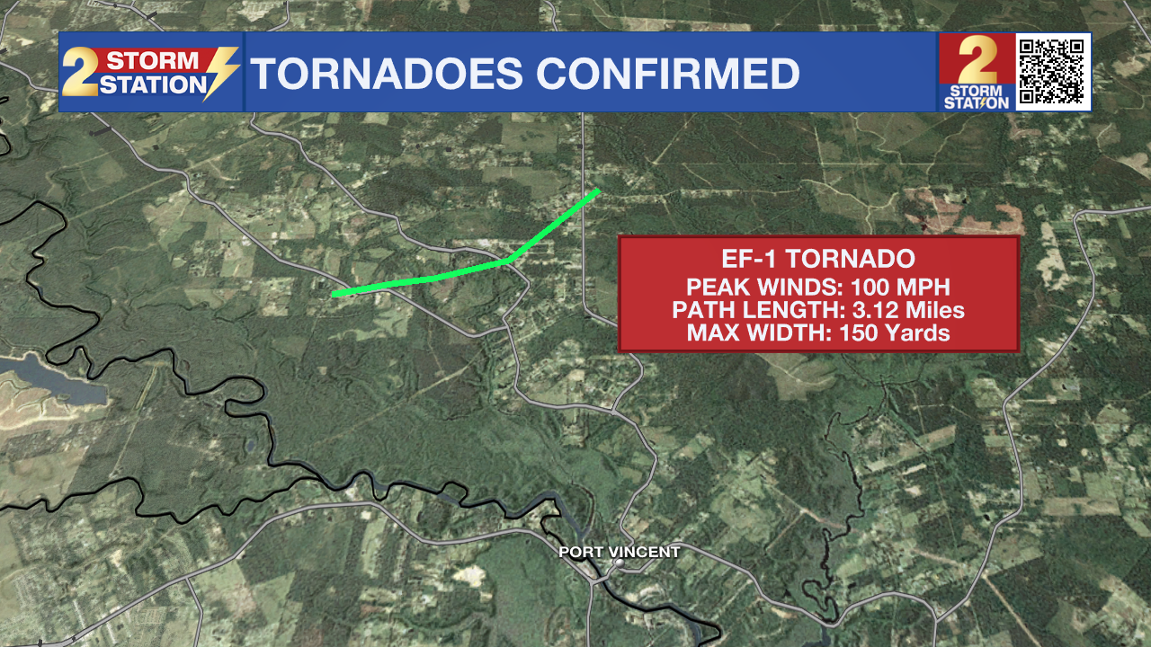
Tornado #3 - Livingston Parish:
Damage surveys indicate that an EF-1 tornado occurred near Port Vincent, with estimated peak winds at 95-100 mph. This tornado tracked for 3.12 miles and was on the ground from 7:23 p.m. to 7:27 p.m.. Ground survey crews in tandem with high resolution satellite analysis noted extensive tree damage from Highway 1032 up to Hammack Road near Walker South Road. The tornado then broadened out into a swath of damaging straight-line winds as the former tornado continued northeast.
All of the damage occurred within a large line of thunderstorms which tore across the region between 6:30 - 8 p.m. on Monday, May 13th. Scattered wind damage and power outages occurred all across the Metro Area as a result.
Another round of severe weather passed through later in the week on Thursday, May 16th. Those storms also brought extensive straight-line wind damage, and dropped a tornado in St. James Parish.
The Storm Station is here for you, on every platform. Your weather updates can be found on News 2, wbrz.com, and the WBRZ WX App on your Apple or Android device. Follow WBRZ Weather on Facebook and Twitter for even more weather updates while you are on the go.
More News
