

Latest Weather Blog
Daily showers and thunderstorms through the week
The active pattern is underway. Scattered showers and thunderstorms will be a part of the forecast for the near future.
Next 24 Hours: Though daytime warming will play a big role in showers and thunderstorms over the next several days, an upper level disturbance moving across the area tonight may keep periods of rain in play overnight and especially closer to daybreak Wednesday. With a more humid air mass in place, low temperatures will struggle to leave the 70s. On Wednesday, any morning activity should find a lull and give way to some peeks of sun. Afternoon thermometers will top out in the mid 80s with scattered showers and thunderstorms firing off for about 50 percent of the forecast area after that.
It has been a while since we talked about rain coverage—the percentages on the forecast board often seen during the warm season. Here is a quick reminder about what those mean for the WBRZ Weather 13 Parish, 3 County forecast area.
10-30% - Isolated: a few locations receive measurable rain
30-60% - Scattered: part to half of the area receives measurable rain
60-100% - Widespread: almost all of the area receives measurable rain
Keep in mind, those chances tell nothing about timing. For instance, 100% DOES NOT mean it will rain all day. We will be sure to provide information in our forecasts as to when you can expect rain when chances are on the board. MORE: https://www.wbrz.com/news/a-chance-to-remember
Trending News
Up Next: An active pattern will ensue through the week and into the weekend. Scattered showers and thunderstorms are on the forecast board each day. Daily coverage may vary between 50 and 80 percent and afternoons should be the most active times though nights may not be exclusively dry. Some of the finer details will be best pointed out from day to day. Through Tuesday, an additional 2-4 inches of rain is expected across the area but a locally higher total could occur if some spots are repeatedly hit with heavier thunderstorms. Temperatures will be rather consistent with highs in the mid 80s and lows in the low 70s. CLICK HERE for your full 7-Day Forecast.
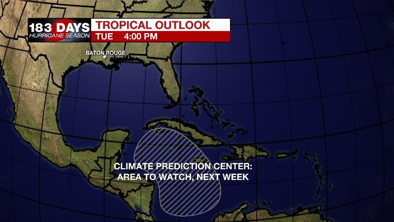
The Tropics: On the first official day of hurricane season, there are no areas of interest in the Gulf of Mexico, Caribbean Sea or Atlantic Ocean. No tropical development is expected over the next five days. However, the Climate Prediction Center has highlighted an area in the western Caribbean Sea that could provide favorable conditions for tropical development next week. Be sure to visit the WBRZ Hurricane Center as we prepare for 183 Days of Hurricane Season.
The Explanation: An upper level trough will anchor across the middle of the country through Thursday. Locally, the atmosphere will respond by cooling and becoming more unstable. Coupled with increasing moisture at the surface and ample heating, as is expected in June, and convection will have no problem developing each day. Scattered coverage is expected each day with the potentially for a few days to have widespread rain. While wind shear is often limited as we move into the warm season, very high instability and moisture can result in downpours and gusty wind so those hazards are possible with any stronger thunderstorms over the next week. While the center of the upper level trough may cross the region on Thursday, the active pattern may not necessarily ease, as generally cooler and more unstable air will linger in the region through the weekend.
--Josh
The WBRZ Weather Team is here for you, on every platform. Your weather updates can be found on News 2, wbrz.com, and the WBRZ WX App on your Apple or Android device. Follow WBRZ Weather on Facebook and Twitter for even more weather updates while you are on the go.
More News
