

Latest Weather Blog
A chance to remember
The forecast this week has made frequent mention of the “summer-like” pattern expected to take hold through the weekend. While that could easily be interpreted as warm and humid, which it will be (not to July levels), the forecast is referencing a difference in precipitation production. To this point in the calendar year, rainfall has primarily been the result of low pressure systems, warm or cold fronts and upper level disturbances. But in the upcoming days, those processes will take a backseat. Numerous blogs on wbrz.com/weather through the years have addressed the causes for these tricky to forecast but typical Gulf Coast patterns. This is a collective look at those factors and a reminder that if you don’t pay closer attention to the forecast (beyond apps and one-caption images), you can get burned by the PoPs!
CONVECTION: transport of heat and moisture by the movement of a fluid
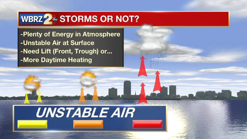
A difference in temperature and moisture content from the surface to the upper levels can also be referred to as instability. As long as warmer, more humid air lies beneath relatively cooler and drier air, the atmosphere is unstable and air will have a tendency to rise. This is a process noted within your own home, as upper floors tend to be warmer than those beneath. Warmer air, rising into cooler air condenses, forming clouds and, if enough instability or external processes are at work, eventually cloud droplets will grow too large and fall as rain. Showers and thunderstorms can develop via CONVECTION alone with no other forcing mechanisms at work.
RIDGES AND TROUGHS: areas of higher and lower atmospheric pressure
Trending News
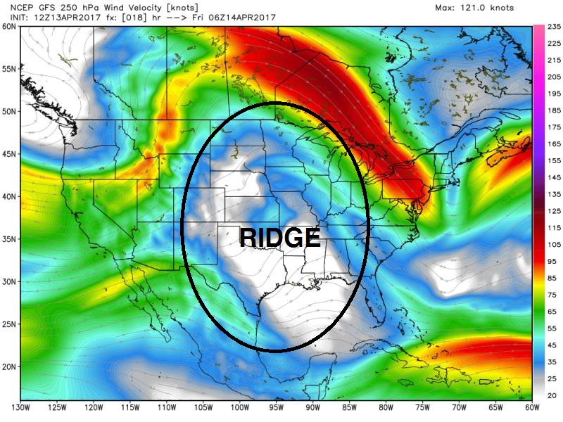
A RIDGE is a pocket of higher air pressure and thus warmer air aloft. Due a decreased temperature change with height, even on the hottest day, the atmosphere is capped and air cannot efficiently rise. With less rising air, we see fewer showers and have fewer clouds and as a result see more sunshine. Ridges lead to clearer, hotter and drier days. Ridges are like a lidded bottle of soda, even when shaken (unstable), with the cap on, nothing happens.
A TROUGH is a pocket of lower air pressure and thus cooler air aloft. With a much steeper change in pressure from surface to sky, air can rise more freely. With more rising air, clouds are numerous and shower and storm development is common. Troughs lead to a stormier pattern with slightly cooler temperatures. Troughs are like a shaken (unstable) bottle of soda, with no lid on to stop them from bubbling up.
For most of the warm season, in the absence of a strong ridge or a deep trough, the WBRZ Weather forecast area may expect isolated, convective showers and thunderstorms—those that bubble up on daytime heating alone. Especially without an established sea breeze or some other small scale weather boundary, determining exactly where this activity will pulse is almost impossible until rain has already started.
However, our science will allow us to issue some more general PoPs—probability of precipitation—for a larger area based on a number of factors available to forecasters. To review, the National Weather Service defines a PoP as “the probability of precipitation for a given point over a specified time” (usually one day or 24 hour period). Since the WBRZ Weather Team forecasts for 13 Parishes and 3 Counties, that is the given point and each day is the given time period. So if you get forecasts from the WBRZ Weather Team, a 30 percent chance displayed on the 7-Day forecast means there is a 3/10 chance that rain will fall at your home, or that about 30 percent of the whole forecast area should receive rain at some point on that day.
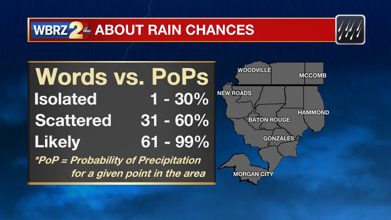
“Boy, that seems awfully vague!” Indeed, PoPs are a component of weather forecasts with a lot of leeway and a lot of uncertainty. Forecasters do have some ability beyond posting a seemingly random percentage though. There are days when we might be able to say, "isolated, afternoon showers and thunderstorms are possible, especially west of I-55." Sometimes we might be able to anticipate development near the coast first based on a sea breeze.
For these reasons, a 7-day forecast graphic, a weather bulletins board or even one forecast model snapshot will not tell the entire weather story. A broadcast presentation, online stories, blogs and posts to Twitter and Facebook offer up the important details of exactly how those PoPs will affect your day on an hour-by-hour basis.
Isolated showers possible as a front moves in today, will not make it through to change temps | #LaWX #MsWX pic.twitter.com/NiI0FaS7jh
— Josh Eachus (@DrJoshWX) April 11, 2017
For YOUR forecast, stick with the WBRZ Weather Team on WBRZ News2, wbrz.com/weather, Facebook and Twitter. Additionally, the *free* WBRZ WX App. puts all of our resources into the palm of your hand with push alerts for changing weather in addition to watches and warnings.
More News
