

Latest Weather Blog
Busy weather next three days
From scattered showers, to severe storms, to falling temperatures the Baton Rouge area will experience an array of changing weather through Tuesday.
Today and Tonight: The new week begins cloudy and rainy. Expect an overcast day with periods of rain across the region. Highs will be near 70 degrees with calm winds. Overnight, skies will remain cloudy with a low in the upper 50s. A lingering shower will be possible.
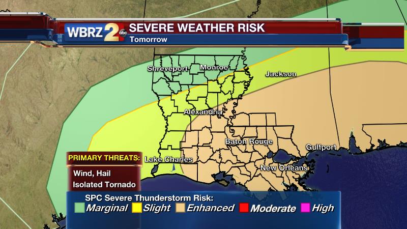
Up Next: Tuesday we will all have to monitor the potential for severe thunderstorms. Another fast moving system will come into the area with a line of showers and thunderstorms expected. Ingredients will be in place to support thunderstorms capable of hail, damaging wind and maybe one or two tornadoes. Highs will be in the low 70s, with southerly winds increasing to 15-20mph. Showers are expected to wrap up by midnight with much colder air arriving for Wednesday Morning as winds turn northerly. Lows will be back into the 40s. Wednesday will remain cool with gradual clearing and a high in the upper 50s. Slightly cooler than average, but dry, conditions will wrap up the week.
Trending News
Meteorologist Josh Eachus provides a detailed video analysis of the severe weather setup, RIGHT HERE.
THE SCIENCE:
Forecast Discussion: An upper trough will swing out of the Midwest into the Gulf Coast region through Monday. Warmth and moisture in place from the weekend will allow positive vorticity advection associated with the trough and associated front to develop widespread rain across the region. Instability is marginal so a thunderstorm or two will also be possible. Forecast models are generally in good agreement for 0.5 – 1.00” of rain across the area. Rain will taper as the trough axis pulls east on Monday Night, providing a brief lull in the action. Then, things get interesting. A second upper wave will be racing from the California Coast to Texas by Tuesday. This trough will be accompanied by much better dynamics for thunderstorms—possibly severe. A surface low will develop at the foot of this trough and push eastward on Tuesday. Forecast models show instability, or CAPE, in the 1,000 range. Helicity values are expected to be impressive, very supportive of rotating updrafts. The deepening trough will stack with the surface low creating upper height falls or a sharply cooling atmosphere. Not only will this increase instability but also increase the cold air available for hail. The Storm Prediction Center is justifiably carrying an enhanced risk of severe weather for the area with all of this noted. All threats are on the table including hail, damaging winds and tornadoes. As quickly as that system arrives, it will push out with cool air rushing in behind it. A few mornings in the upper 30s are anticipated before more seasonable air returns on Friday. Dry conditions will prevail through the weekend.
--Josh
Twitter: @Josh_Eachus
Google+: Josh Eachus
Facebook: Meteorologist Josh Eachus
More News
