

Latest Weather Blog
Bitter cold will send the area into a HARD FREEZE
Significant cold temperatures will overspread Louisiana and Mississippi on Thursday night and last through Christmas.
A polar airmass is expected to surge to the Gulf Coast Thursday night and will bring several hazards to the area. Both *HARD FREEZE* and *WIND CHILL* alerts are active from Thursday night through Christmas Day. Thursday should be used to finalize measures to protect family, friends, pets and property from the likelihood of extreme and prolonged freezing conditions.
Get the latest forecast and real time temperature updates HERE.
Watch live news HERE.
Trending News
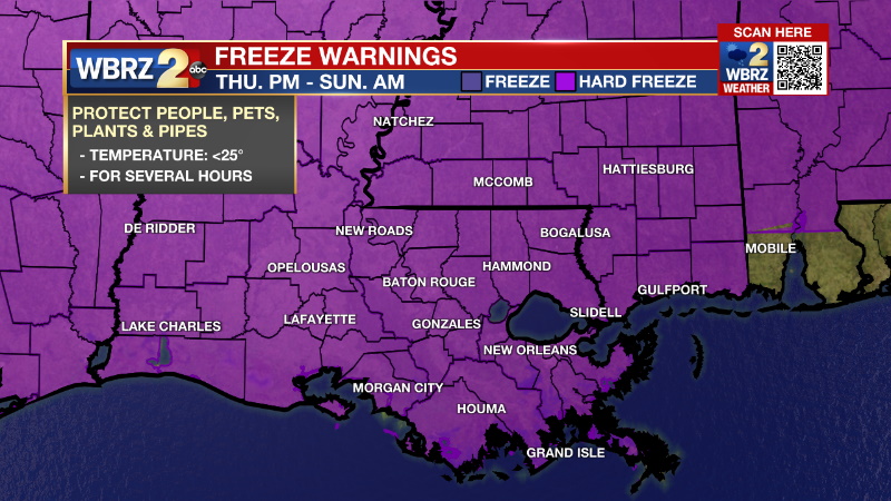
A HARD FREEZE WARNING will start on Thursday evening and last into Sunday morning for for temperatures dropping below 25° for several hours. Significant warming is not expected until Sunday afternoon.
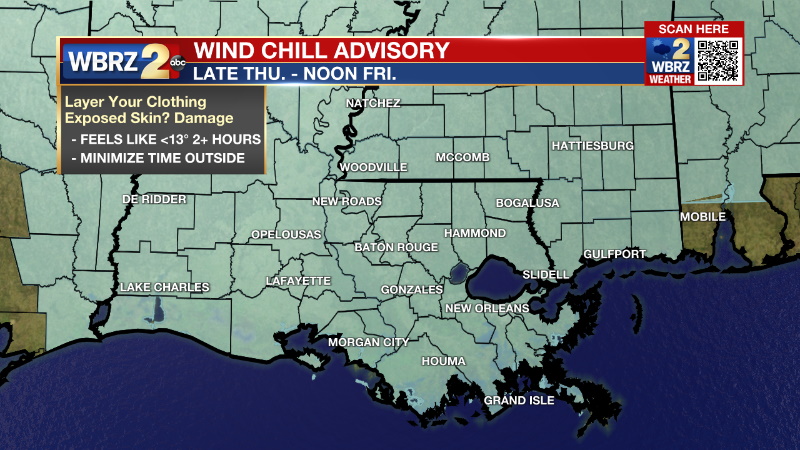
A WIND CHILL ADVISORY will go into effect as the front comes through on Thursday evening. The wind chill could be near 0° into Friday morning.
A strong, polar cold front will rush into the area during the evening hours causing a stark 20 degree temperature drop in just about 2 hours followed by lows that ultimately make it into the low 20s. The Baton Rouge area will likely dip into the teens for a short time. As the front comes through, a few brief showers will be possible before the temperatures drop. A few flurries could fall as the precipitation ends, but this chance is very low and there is no chance for accumulation. Winds will really pick up once the front passes and, in combination with very dry air arriving, any damp spots will evaporate quickly to eliminate a threat for ice. Blustery north winds of 15-25mph will prevent much warming on Friday as temperatures are expected to stay below freezing, despite sunshine. The feels-like temperatures, or wind chills, will be in the teens for most of the day. Not much change is expected on Saturday. Christmas Day will begin with a hard freeze but thermometers should make it above 32° for a few hours in the afternoon and the winds will finally ease up as well. Fortunately, no precipitation will be in the mix to cause additional problems. Cold, below average temperatures will last through Tuesday before temperatures begin to moderate. Wednesday and Thursday, highs will be in the 60s and 70s, respectively. CLICK HERE for the full 7-day forecast.
Cold Weather Hazards:
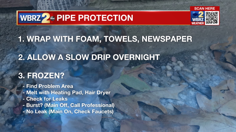
1) By dawn Friday, a HARD FREEZE will be ongoing with temperatures in the low 20s and thermometers may not climb above freezing for more than 36 to 48 hours. Expect a HARD FREEZE with temperatures in the low 20s or teens Friday night, Saturday night and Sunday night as well. Be sure to insulate and wrap any exposed outdoor pipes and faucets.
2) Behind the front winds will come from the north, rapidly increasing to 10-20mph with higher gusts. The north winds will be running perpendicular to the major local interstates causing a potentially dangerous cross wind for work and holiday driving, especially in high profile vehicles. Also, holiday decorations will release if not secured well. Lastly, any gusts over 25mph could cause some minor tree or electric line damage and isolated outages. This will not be a widespread issue but a possibility to keep in mind. Have a way to keep warm in case power is lost.
3) The blustery conditions will result in biting wind chills. With air temperatures in the 20s and 30s, winds of 10-20mph will be enough to cause feels-like temperatures in the teens and perhaps single digits. These conditions are very dangerous to people and pets so be sure to bundle and avoid much skin exposure or minimize time outside. Both hypothermia and frostbite can develop in just minutes in the expected conditions.
Go INSIDE THE WEATHER to find out more about the dangers of this major cold blast.
--> How does wind chill affect us and our homes?
--> What is a hard freeze and what is the impact?
(((Following Data courtesy of National Weather Service)))
Every event is different and should be treated as such, but for some modern reference, here are a few relatable cold outbreaks:
-February 2nd through 5th 1996
-January 8th through 11th 2010
-February 15th through 17th 2021.
This cold blast will likely be more potent than the 2021 event. However, IT WILL NOT be accompanied by significant wintry precipitation thereby eliminating the risk for ice induced power outages.
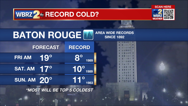
As for a reference to Christmas, surprisingly there are two relatable historic events:
-December 23rd through 26th 1983
-December 22nd through 25th 1989
These two were extreme events and at this time we are not expecting to test those records. The 1989 cold airmass still holds numerous records across a good portion of the United States including locally where single digits were recorded in many places. We would have to go back to 1899 to see temperatures recorded lower than 1989 in much of the area over a multi day stretch.
As we move toward the holiday season, follow your weather with The Storm Station. WBRZ Weather is here for you, on every platform. Catch the latest updates can be found on News 2, wbrz.com, and the WBRZ WX App on your Apple or Android device. You can also follow WBRZ Weather on Facebook and Twitter for even more weather updates while you are on the go.
More News
