

Latest Weather Blog
Active local weather and systems stirring in the tropics
Scattered showers and storms stay locked in to the local forecast. In the tropics, Florence will be coming together in the eastern Atlantic, and some development is possible in the northeast Gulf late next week. Far out and with little detail available, the latter is just a scenario to monitor for now.
THE FORECAST:
Today and Tonight: Nothing new to see here… after high temperatures in the low 90s, Friday will bring scattered showers and thunderstorms, mainly from late morning to late afternoon. Skies will partially clear overnight with lows in the low to mid 70s.
Up Next: A surge of tropical moisture may bring an uptick in rain coverage over the weekend. As thermometers approach 90 degrees, scattered to widespread showers and thunderstorms will develop. Torrential rain and frequent lightning can be expected with any storm. Keep in mind, if you will be enjoying the outdoors this weekend, head inside (four walls and a roof) if you can hear thunder. Nights will be quieter aside from coastal showers near daybreak with lows in the mid 70s.
#GeauxTigers & #GeauxJags... rep #BatonRouge with pride in Texas! pic.twitter.com/wCm3BkHeA6
— Josh Eachus (@DrJoshWX) August 31, 2018
Trending News
Football Is Back: For those making a trek to Dallas and Forth Worth this weekend, the key weather feature will be heat. Afternoon high temperatures will be in the mid to upper 90s with overnight lows in the mid to upper 70s. No rain is in the picture. Southern gets the party started on Saturday at TCU with a kickoff temperature of 90 degrees and an end of game temperature closer to 100 degrees. LSU fans will feel that heat before the game inside of AT&T Stadium and will exit the building to thermometers in the mid 80s.
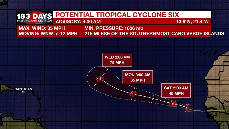
The Tropics: Disorganized showers and thunderstorms moving off the coast of Africa are associated with a strong tropical wave and broad area of low pressure. Potential tropical cyclone six will become a more well-defined low pressure system near the Cabo Verde Islands. The designation is because the yet undeveloped system is expected to bring tropical storm conditions to the islands. A depression or storm is likely to form by the weekend while moving west-northwestward at about 15 mph. Then the system is expected to continue into the central Atlantic, possibly becoming hurricane Florence, but poses no immediate threat to the United States.
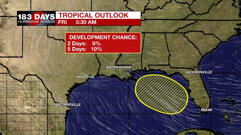
Much closer to home, a tropical wave zipping across the Caribbean Sea may help to develop a trough or weak area of low pressure at the surface near Florida after the weekend. The Weather Prediction Center is now including this system on their forecast maps. Computer models have shown a number of scenarios that indicate some development is possible with a system moving into the Gulf of Mexico during the middle of next week. That same area of high pressure that has kept the local weather so persistent, sticky and stormy of late will remain in place to steer any system generally west-northwestward through the Gulf. Keep in mind though, models perform poorly when no system has developed to track. Therefore confidence is low in any strength, timing, track or if a storm even develops in the first place. At this point, we just need to keep an eye on the forecast as even the weakest disturbance in the Gulf can bring a heavy rain threat.
THE EXPLANATION:
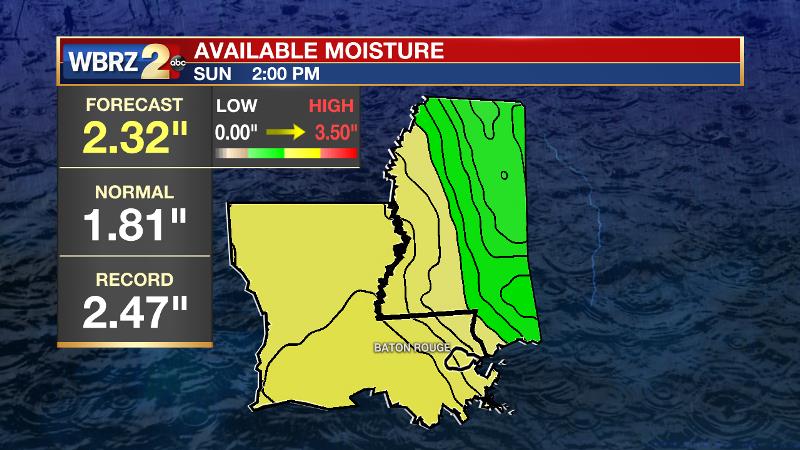
An upper level ridge of high pressure will remain centered over the western Atlantic Ocean and northeastern U.S. leaving minimal subsidence in place over the central Gulf Coast. At the surface, high pressure over the Mid-Atlantic will continue to allow deep southeasterly flow to keep lots of moisture over the region. Precipitable water or available moisture in the atmosphere will increase to 2.25 inches, nearly a record for the time of year, over the weekend. As a result, measurable rain coverage will increase from 40 to 50 percent to 60 to 70 percent. In terms of temperatures, outside of storm influences, highs should be near average each day. Torrential rain will be possible due to the high moisture content, storm motion will have to be monitored as slow-movers could lead to localized flooding. Not much will change next week. The Weather Prediction Center is depicting an area low pressure developing near Florida on Tuesday in response to a westward bound tropical wave currently moving through the Caribbean Sea. Forecast models have latched on to this wave and been showing a closed circulation developing in the northeastern Gulf. The strong area of high pressure in the western Atlantic is likely to stayed locked in place sending impulses and any tropical systems that can develop from east to west across the Gulf. The GFS model has been the weaker and further west solution while the ECMWF has been the stronger and further east solution. The bottom line is that as effective as forecast models can be, they are limited when it comes to tropical systems that have not yet formed. Confidence will be low and details unclear until a system forms and we get closer in time. Continue to monitor this scenario for now.
--Dr. Josh
The WBRZ Weather Team is here for you, on every platform. Your weather updates can be found on News 2, wbrz.com, and the WBRZ WX App. on Apple and Android devices. Follow WBRZ Weather on Facebook and Twitter for even more weather updates while you are on the go.
More News
