

Latest Weather Blog
A hot week of rebuilding; the latest on T.D. 9
A week of high late summer heat and humidity is ahead as Louisiana residents side-eye the tropics.
THE FORECAST:
Today and Tonight: For one more afternoon, expect scattered showers and thunderstorms across the area. Rain coverage for the 13 Parishes and 3 Counties will end up in the 30-percent range. The best bet for a shower will be south of I-10. High temperatures will still manage the lower 90s with no break in humidity. Overnight, a partly cloudy sky is expected as lows fall into the mid 70s.
Up Next: Tuesday through Thursday will bring more heat and fewer storms. While a stray shower could flare up on heat alone, instability will be a bit more limited and thus more locations will remain dry each day. As skies stay sunny longer and in more locations, high temperatures will rise into the mid 90s. Humidity is not expected to break and therefore it is possible that we have another stretch with feel-like temperatures in the 105 degree range. Overnight lows will keep in the mid 70s.
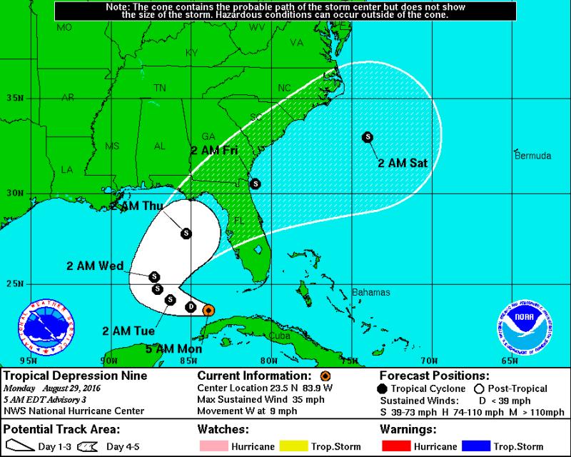
The Tropics: Tropical Depression Nine is currently positioned just northwest of Havana, Cuba with a minimum central pressure of 1007mb and maximum sustained winds of 35mph. Moving to the west at 9mph, the system is expected to strengthen achieving tropical storm status. While it may be painstaking to watch lingering in the Central Gulf of Mexico, at this time, our most reliable information suggests that eventually a turn to the northeast and the Florida Coast is anticipated. Certainly continue to monitor the forecast as a change in track could mean big changes for the local area. Take this time to review hurricane preparedness and have your game plan installed should it be needed.
Trending News
THE SCIENCE:
Forecast Discussion: A broad upper level ridge of high pressure will spread west and become a much greater influence over our region by Tuesday and Wednesday. That upper ridge will lead to strong subsidence, or sinking air aloft, thus causing the atmosphere in the mid and upper levels to dry and warm. This should produce a fairly strong temperature inversion in the mid-levels. This inversion will greatly reduce the amount of instability in the atmosphere and stunt cloud development. Rain coverage will be fairly low across northern locations with better daily chances south of I-10. Convection has been a bit faster moving of late, so rainfall rates should be low enough to not produce any significant flooding issues even with the saturated grounds. With regard to temperatures, expect highs to rise into the middle 90s each day due to the combination of subsidence and strong solar insolation. With dewpoints lingering in the lower 70s at the surface, heat index values of 100 to 105 degrees will be possible Tuesday and Wednesday. Now onto the tropics…Tropical Depression 9 will drift slowly west and should be somewhere over the East-Central Gulf of Mexico by Wednesday Afternoon. Fortunately, with the strong upper level ridge parked over us, this system should remain well displaced from the forecast area. A weak front may move into the area late week, further deflecting the tropical system eastward and maybe increasing our daily rain and storm chances. Therefore, the biggest impact from Tropical Depression 9 will be a sustained easterly wind of 15 to 20 knots that could push tides up 1 to 2 feet above normal on east facing shores.
You can stay in touch with Meteorologist Josh Eachus on FACEBOOK and TWITTER.
More News
