

Latest Weather Blog
A few inches of rain expected over the next several days
A few periods of rain and thunderstorms are in the forecast through the first half of the weekend. Do not expect any major temperature changes with highs in the 80s and lows in the 60s.
Next 24 Hours: Especially for hours that received some rain on Tuesday, patchy fog will be possible into Wednesday morning. Otherwise, skies will be partly cloudy with low temperatures in the low 60s. Much of Wednesday should work out to be dry and mild with high temperatures climbing into the low 80s. You will notice a south breeze of 10-15mph. Late in the day, mainly northwest of Baton Rouge, a couple of showers and thunderstorms could develop. A much better chance of showers and thunderstorms will come overnight as a weakening line moves through the area. One or two thunderstorms could produce gusty wind and downpours.
Wednesday is National "Safe Place Selfie" Day! We join our partners at the National Weather Service in promoting and teaching severe weather safety. CLICK HERE to learn more and be sure to send your safe place selfie to weather@wbrz.com so we can share it on social media!
Up Next: Most of the action will end before daybreak on Thursday followed by a relatively quiet afternoon. Friday into Saturday, a strong upper level storm system and cold front will move into the region. Ingredients do not look favorable for widespread severe weather but gusty wind, isolated hail and a round of heavy rain are all possible. Including rainfall from Wednesday night, much of the area could pick up 2-4 inches by Sunday. As always, an isolated higher amount is possible. Wet weather may take a pause for the second half of the weekend but temperatures will stay above average. CLICK HERE for your full 7-Day Forecast.
Trending News
The Explanation: By late Wednesday, a cold front will move into the Arklatex region with an ongoing round of showers and thunderstorms. This activity is expected to race ahead of the boundary, weakening on approach to the local area but should maintain enough integrity to produce scattered to widespread showers and thunderstorms overnight.
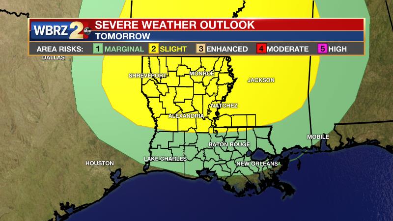
While the SPC added a “slight risk” of severe weather north of I-12 and maintained a “marginal risk” elsewhere, the nighttime arrival and loss of forcing away from the front should preclude a significant threat. The cold front will only crawl toward the central Gulf Coast through Saturday. Actually, a slightly drier air mass will take hold on Thursday leading to a primarily dry afternoon. A vigorous upper level trough will then push into the Midwest on Friday and drive the front farther to the southeast. Scattered to widespread showers and thunderstorms will fire up Friday afternoon and may continue into Saturday morning due to the approach of the front and favorable winds in the upper levels of the atmosphere. Gusty wind, hail and downpours will be possible with any thunderstorms. Forecast models and the Weather Prediction Center all agree on a range of 2-4 inches, with locally higher amounts, across the forecast area through Saturday. The second half of the weekend will feature improved weather with dry, sinking air taking hold. Through the weekend, expect above average temperatures with highs in the 80s and lows in the 60s. Another front will likely pass through the area early next week with another chance of showers and thunderstorms but also a more prolonged stretch of cooler, drier weather behind it.
--Josh
The WBRZ Weather Team is here for you, on every platform. Your weather updates can be found on News 2, wbrz.com, and the WBRZ WX App on your Apple or Android device. Follow WBRZ Weather on Facebook and Twitter for even more weather updates while you are on the go.
More News
