

Latest Weather Blog
Sunday Afternoon Forecast
Related Story
Bringing the HEAT for the workweek
THE FORECAST
Tonight & Tomorrow: Temperatures are overachieving today, topping out near 93° across the area. The dense cloud cover this morning dd not stop the heat from making its way in. Some cloud cover still hangs around as we head into the evening hours. As the sunsets temperatures will fall into the low-70s overnight. With some moisture still in our atmosphere there is a chance for some areas to see reduced visibility again tomorrow morning. As the sun begins to rise the fog will lift and temperatures will rapidly heat into the low-to-mid 90s. With the low humidity temperatures will have plenty of opportunity to get on the steamy side, creeping well above average for this time of year. Some cloud cover will build into the area, and a shower is possible as we head into the afternoon hours. As the sunsets any shower activity will dissipate and the clouds will move out. Overnight temperatures will fall into the low-70s.
Up Next: Tuesday will be dry. Some might even say Tuesday will be pleasant, other will say it is HOT. Waking up temperatures will be in the 70s with mostly sunny skies. Tuesday we will see even more drying out in the forecast. Throughout the day skies should stay clear and with the lack of humidity temperatures will rocket into the mid-90s. Not expecting any rain in the forecast. For the rest of your work week, expect more heat and less humidity in the forecast. Starting your day temperatures will be in the 70s, gradually rising into the low-90s throughout the day. Rain chances stay on the lower side for most of the week and humidity stays a little lower. Not quite fall yet… but drier conditions are expected for your workweek. Click here to see the 7-day forecast.
The Storm Station has you covered with hour-by-hour weather tracking is available for your location on the WBRZ WX App on your Apple or Android device. Follow WBRZ Weather on Facebook and Twitter for even more weather updates and unique weather insight from the whole team!
In the Tropics:

As of 4 pm Sunday, Hurricane Fiona is now moving over the western portion of Puerto Rico approaching the eastern Dominican Republic with maximum sustained winds of 85mph. Moving northwest at 9mph, Fiona will continue on this track towards the northwest. Some gradual strengthening is expected today and into Monday. Hurricane force winds and torrential rain are expected across the Puerto Rico, Dominican Republic, and Turks and Caicos. Localized areas in Puerto Rico area projected to pick up 30 inches of rain.
Central Subtropical Atlantic:
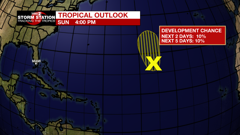
Disorganized showers and thunderstorms continue over the central
subtropical Atlantic in association with a weak trough of low
pressure. Significant development of this system is becoming less
likely while it moves generally northward for the next couple of
days, remaining over the central subtropical Atlantic.
* Formation chance through 48 hours...low...10 percent.
* Formation chance through 5 days...low...10 percent.
News
