

Latest Weather Blog
Wednesday PM Forecast: temperatures set to gradually warm
An extended dry stretch is underway. Temperatures will gradually climb from average to above average.
Next 24 Hours: With clear skies and light winds, Thursday morning will attempt to match Wednesday low of 62 degrees. Many locations will bottom out between 62 and 64 degrees. Thursday will be another day with mainly sunny skies and lower humidity. Afternoon highs will reach the mid 80s.
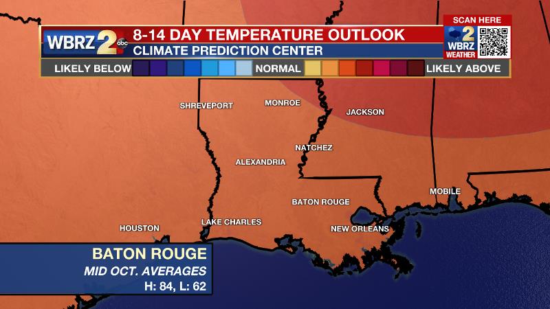
Up Next: Into the weekend, saturated soils will have a chance to dry out a bit. Friday will be mostly sunny with lows in the mid 60s and highs in the mid 80s. Over the weekend, sunny afternoons will allow gradually warming high temperatures with some mid to upper 80s by Sunday. Even though nights will stay clear, low temperatures will also bump up a degree or so each morning. It no longer looks like a cold front will enter the region early next week. This will spell persistent weather and therefore warm, above average temperatures. Days will be mostly to partly sunny and rain chances will stay low to non-existent. CLICK HERE for your full 7-Day Forecast. Looking to the extended, 8 to 14-Day period, the Climate Prediction Center shows a strong probability for above average temperatures through next weekend.
The Tropics: A weak area of low pressure has been trying to develop east of Florida, but the associated shower and thunderstorm activity remains disorganized due to strong upper-level winds. As the low moves northward, there is a 20 percent chance of formation before the system interacts with a front this weekend. For the latest tropical forecasts, advisories and information, visit the WBRZ Hurricane Center as we navigate all 183 Days of Hurricane Season.
Trending News
The Explanation: The upper level low pressure that has been parked over Mississippi and Alabama for a few days will shear out into a trough and lift northeastward through the end of the week. With the local area on the southwest side of this system now, dry air has spilled in and resulted in the first of many days without precipitation. Behind the associated surface front well east of the area, dew points remain in the low to mid 60s, which is allowing for a slightly less humid feel. Similar conditions will persist through Friday. Since conditions will not change much, temperatures on Thursday and Friday will mimic Wednesday with lows in the low 60s and highs in the low to perhaps mid 80s. An upper level ridge of high pressure will build over the region over the weekend. With continuing dry air, afternoon highs will climb into the mid to upper 80s thanks to ample sunshine. The ridge will likely stay anchored over the area through early next week, which will send any troughs well north, and west and keep a front from penetrating Louisiana and Mississippi. Moisture will struggle to return to average for the time of year so the rain coverage forecast will stay very low at 10 to maybe 20 percent.
--Josh
The WBRZ Weather Team is here for you, on every platform. Your weather updates can be found on News 2, wbrz.com, and the WBRZ WX App on your Apple or Android device. Follow WBRZ Weather on Facebook and Twitter for even more weather updates while you are on the go.
More News
