

Latest Weather Blog
Wednesday PM Forecast: fizzling front may bring light showers
A weak frontal system will bring a period of clouds and spotty showers as cooler air arrives before the workweek is over. The first full weekend of November will bring pleasant fall weather and an extra hour of sleep!
Next 24 Hours: As a cold front and associated low pressure slip through the area, expect cloudy skies and a few rogue showers overnight. Temperatures will ease back behind the front and bottom out in the low 50s by dawn. While leftover, spotty showers may only linger for a few hours into Thursday, the clouds will be a bit more stubborn. Gray skies will hold thermometers in the low 60s.
Up Next: By Friday, some clearing will occur with cooler air still seeping in behind the front. Average highs and lows this time of year are 75 and 51 respectively and temperatures should be below that with mainly clear skies through the weekend. By next Tuesday and Wednesday, winds will shift southeast, a few clouds will start to develop and high temperatures will take a run into the mid to upper 70s. The next earliest chance for rain appears to be at least a week away. CLICK HERE for your full 7-Day Forecast.
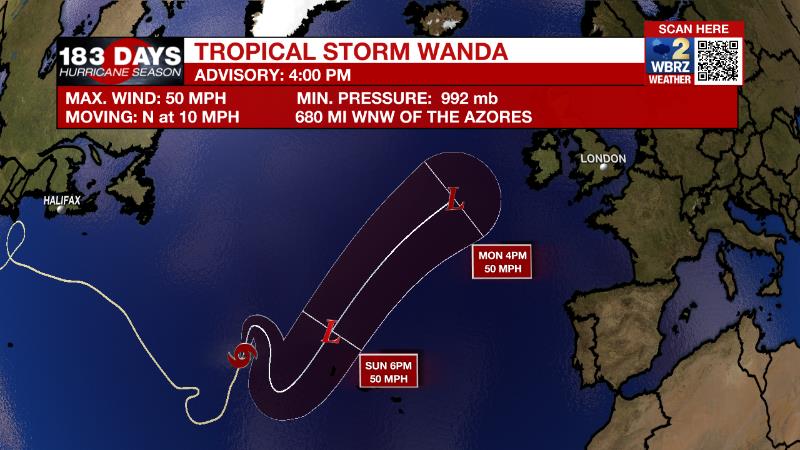
The Tropics: Tropical Storm Wanda has maximum sustained winds of 50mph and is moving north at 10mph over the North Atlantic. This system could strengthen slightly on a northeast trek out to sea through the week. Wanda will not affect North America. For the latest tropical forecasts, advisories and information, visit the WBRZ Hurricane Center as we navigate all 183 Days of Hurricane Season.
Trending News
The Explanation: A positively tilted (and therefore less ominous) upper level trough of low pressure will guide a weak frontal system southeastward through the region Wednesday night into Thursday. Those features will result in cloudy skies and spotty, light showers through Thursday afternoon. Amounts will be rather light, with most locations registering little more than a trace. The trough will begin to move east on Thursday afternoon and interact with a weak tropical wave in the Gulf of Mexico resulting in a significant burst of rain and thunderstorms over the open waters. However, the front will keep our area well shielded from that activity. A surface high pressure system will quickly build in behind the front and drier, more stable air will result in clearing conditions on Friday. The high pressure will remain in control through Monday with mainly clear skies, highs in the upper 60s to low 70s and lows in the upper 40s to low 50s. As the high moves east on Tuesday and Wednesday, southeast winds will return some moisture and milder air to the region. The next storm system will likely arrive late next week but it is too early to determine how this will affect our area.
--Josh
The WBRZ Weather Team is here for you, on every platform. Your weather updates can be found on News 2, wbrz.com, and the WBRZ WX App on your Apple or Android device. Follow WBRZ Weather on Facebook and Twitter for even more weather updates while you are on the go.
More News
