

Latest Weather Blog
Unseasonable warmth breaks, pollen does not
Very pleasant weather is in store for the remainder of the week.
THE FORECAST:
Today and Tonight: The second day of March will be welcomed by ample sunshine and seasonable temperatures. Expect highs to top out in the upper 60s with north winds of 10mph. Overnight will be clear and chilly with lows in the mid 40s.
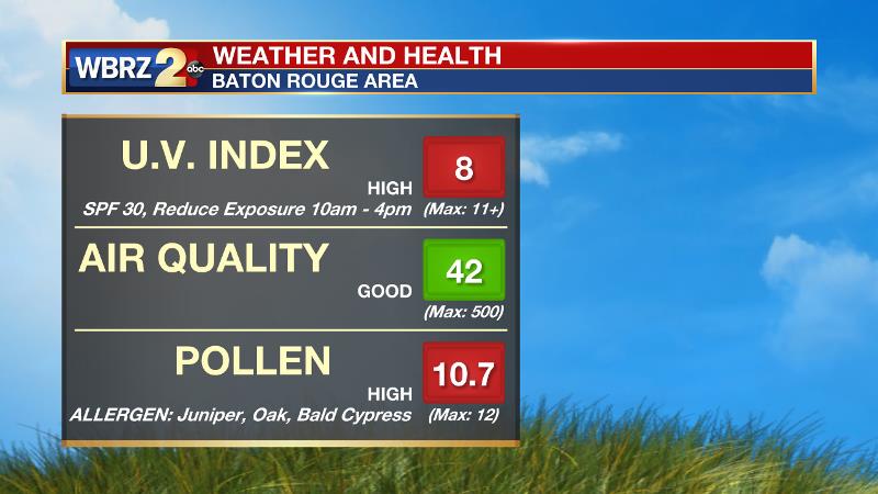
Up Next: Similar weather is on tap for Friday and Saturday but some high, thin clouds may mix in at times. High temperatures will top out in the upper 60s with overnight lows in the mid 40s through Saturday Morning. Winds will be light and northerly and pollen will remain very high heading into the weekend. Bald cypress, juniper and oak are the main allergens right now. A spotty shower is possible Sunday as return flow brings moisture and 70 degree temperatures back to the region.
THE SCIENCE: Surface high pressure will move from the Lower Midwest to the Atlantic Coast from Thursday to Saturday. Northerly surface winds a relatively dry atmosphere will result in mostly clear and seasonable conditions. A few weak pockets of positive vorticity advection may result in times of cirrus clouds Friday and Saturday. A slightly better defined shortwave trough is expected to cross the Gulf Coast on Sunday and with this and inbound moisture thanks to return flow may be enough to produce a more prominent cloud deck and possibly a shower. Still, there isn’t too much with this wave and the ECMWF is more aggressive with the wave and subsequent precipitation than the GFS. More significant model disagreement arises next week as the GFS shows a sharper trough axis and associated cold front crossing the area on Tuesday with up to a half of an inch of rain possible. Meanwhile, the ECMWF is putting forth a much weaker solution, akin to Wednesday’s front. We will include a mention of rain showers for next Tuesday but given the track of the upper level trough, am leaning toward the weaker solution at this time. Temperatures will moderate to average by Sunday and be slightly above into the middle of next week.
Trending News
--Josh
More News
