

Latest Weather Blog
Tuesday PM Forecast: fall to arrive with cooler, dry weather pattern
Autumn begins at 2:20pm local time on Wednesday. Coincidentally, a completely new, fall-like weather pattern will start right around the same time.
Next 24 Hours: A cold front will push across the area tonight with scattered showers and thunderstorms. Do not expect any impactful weather, rather some brief rain and perhaps winds gusting to around 30mph. Low temperatures will trail off into the upper 60s. Behind the front, skies will clear from northwest to southeast on Wednesday morning. A stern northwest breeze will prevent substantial warming, despite the return of sunshine. High temperatures will barely get back to the 80s.
Up Next: Get ready for a run of pleasant weather! Thursday through Sunday will feature mostly clear skies, no humidity, no rain chances, highs in the upper 70s and low 80s and lows in the mid to upper 50s! The last time that temperatures reached 55 degrees or lower was April 26. The last time the area made it five days without rain was June 7-12. CLICK HERE for your full 7-Day Forecast.
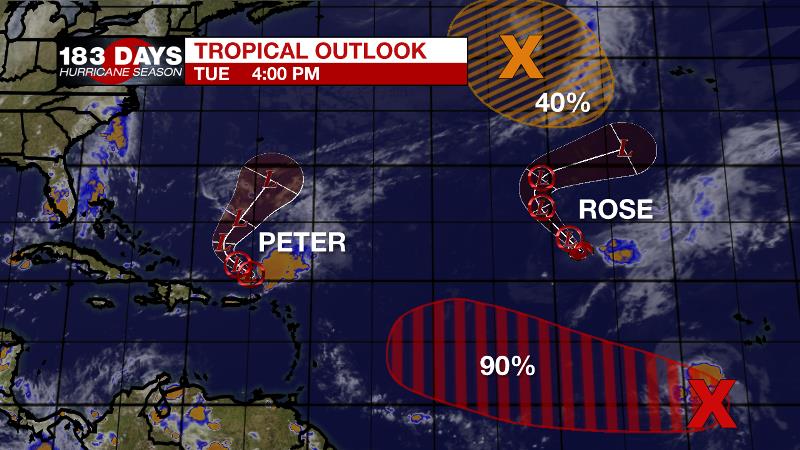
The Tropics: The tropics are busy, but not threatening to the United States. Tropical Depression Peter is struggling with wind shear north of Puerto Rico. It will move to the north, slow and degenerate to a remnant low over the next few days. Tropical Storm Rose is barely hanging on to its status over the eastern Atlantic Ocean. This system will turn north and fall apart by the end of the week. A tropical wave southwest of the Cabo Verde Islands has a 90 percent chance of becoming a tropical depression as it moves westward over the southeast Atlantic this week. The remnants of Tropical Storm Odette over the north Atlantic have a 30 percent chance of acquiring subtropical characteristics as it drifts slowly south later this week. For the latest tropical forecasts, advisories and information, visit the WBRZ Hurricane Center as we navigate all 183 Days of Hurricane Season.
Trending News
The Explanation: A sharp, upper level trough will enter the region tonight. An associated cold front will move in from the northwest. All of the supporting mechanisms for severe weather will be well north of the area so it appears that with an overnight passage, some humidity and lift is all that will be available to produce a broken band of showers and thunderstorms. Any rain will move offshore by Wednesday afternoon. On the other side of the front, northwesterly winds will usher in the coolest air since April. In fact, the temperature effects will be noticed as early as Wednesday afternoon as high temperatures struggle to get back to 80 degrees. Dew point temperatures will fall from the uncomfortably sticky 70s into the dry and pleasant 50s. Beginning Wednesday night, a run of lows in the mid 50s is anticipated! Thursday through Sunday will be dry and comfortable with mainly clear skies, highs in the upper 70s to low 80s and lows in the mid to upper 50s. By early next week, a ridge of high pressure will build overhead leading to warmer afternoons. However, associated sinking air and a dry atmosphere will keep rain off the forecast board.
--Josh
The WBRZ Weather Team is here for you, on every platform. Your weather updates can be found on News 2, wbrz.com, and the WBRZ WX App on your Apple or Android device. Follow WBRZ Weather on Facebook and Twitter for even more weather updates while you are on the go.
More News
