

Latest Weather Blog
Thermometers climb through Wednesday
Look for a warm start to the week as highs approach 90 by Wednesday. A cold front will move into the region by the end of the week.
THE FORECAST:
Today and Tonight: Look for some high clouds to thicken over a mostly sunny sky to start the new week. Southerly winds will take hold over the area, increasing the potential for spotty to isolated showers to develop by the evening. The influx of warmth and moisture from the Gulf of Mexico will guide afternoon high temperatures into the mid 80s. Overnight brings the best shot at a shower, though coverage will be low. Thermometers will stop in the upper 60s.
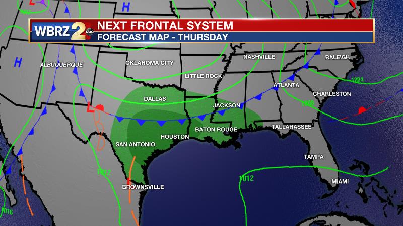
Up Next: Continued onshore flow will aid the development of spotty showers on Tuesday as well. High temperatures will continue to increase through the 80s and approach the 90s on Wednesday. A frontal system will then move into the region on Thursday and Friday. This will bring the potential for showers and thunderstorms, and some cells could be strong. Thermometers will take a turn for the cooler behind that system, and unlike the past couple of frontal passages, this cool air mass will have some staying power.
Trending News
The Mississippi River: At Baton Rouge, major flood stage continues with a level of 42’ as of Monday morning. Around April 11, the river is projected to crest near 43’. The high water is primarily an issue for river traffic and river islands, although some inundation will continue for a few spots north and south of Baton Rouge that are not protected by levees. Unprotected low-lying areas will be flooded and agricultural operations will be impacted on the west side of the river. The grounds of the older part of Louisiana State University's campus become soggy. This includes the area around the Veterinary Medicine building, the Veterinary Medicine Annex, the stadium and ball fields. The city of Baton Rouge and the main LSU campus are protected by levees at this level. This comes after a year where the gauge at Baton Rouge spent a record smashing run of 212 consecutive days above flood stage between January and August. Peaking at 44.1’ on March 19, 2019 the river set its 7th highest recorded crest at Baton Rouge. The level is also high in New Orleans and the U.S. Army Corps of Engineers has opened the Bonnet Carre Spillway. From May to July 2019, the Spillway was open for a record 79 consecutive days during its second opening of the year. If the Spillway is opened in 2020, it will mark the fourth time in five years and the 15th time since being built in 1931.
THE EXPLANATION:
A ridge of high pressure over the Gulf of Mexico will maintain above average temperatures through the middle of the week. While, mainly dry conditions are anticipated, advancing Gulf moisture amidst onshore winds will allow isolated showers to develop. The chances may be enhanced somewhat by some weak upper level impulses riding over the ridge with the best, albeit low, chance for isolated showers overnight Monday and through Tuesday. Wednesday will be the warmest day of the week with high temperatures approaching 90 degrees. Then, a frontal system will move into the region late Thursday. With several days of warmth and moisture priming the atmosphere, showers and thunderstorms should readily develop. This period will need to be monitored for some stronger activity. The first front will knock temperatures down a bit, as it crawls into the Gulf of Mexico. It is expected to stall close enough to the region that clouds and isolated showers will stick around into the weekend. A second front will then move in during the middle of the weekend. While confidence is low at this time, the current forecast is for this front to flush out the lingering clouds and showers and provide a prolonged period of cooler and drier than average conditions into early next week.
--Josh
The WBRZ Weather Team is here for you, on every platform. Your weather updates can be found on News 2, wbrz.com, and the WBRZ WX App. on Apple and Android devices. Follow WBRZ Weather on Facebook and Twitter for even more weather updates while you are on the go.
More News
