

Latest Weather Blog
Sunday PM Forecast: Hot, humid, daily storms this week
Tonight and Tomorrow: We've had a few showers and storms around this evening, which will continue through about 7 or 8pm. All will be dry overnight under a partly cloudy sky. Lows will be in the mid 70s. Monday, basically expect a repeat of today - highs in the lower 90s with pop-up afternoon showers and thunderstorms.
Looking Ahead: Over the next five days, we will see much of the same - highs in the low to mid 90s with a chance for afternoon storms. There won't be any wash outs, but a few brief downpours will be possible each day. Looking ahead towards next weekend, a frontal boundary will approach the area upping rain chances slightly. Click here to see the 7-day forecast.
The Tropics
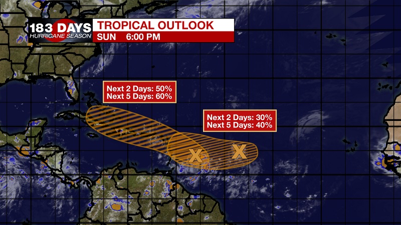
We're monitoring two tropical waves in the Atlantic. Both have a medium chance of formation as they track to the west northwest. Neither pose an immediate threat to the Gulf Coast at this moment.
The more westward tropical wave has been designated as Invest 94-L. This is the main one we will be monitoring, as the computer models do bring the system close to south Florida by next weekend. There is still plenty of time to watch and there are obstacles for these waves to get through. We're moving into the active part of hurricane season, so it's a good reminder to stay up to date with what's going on in the tropics.
-- Jake
Your weather updates can always be found on News 2, wbrz.com, and the WBRZ WX App on your Apple or Android device. Follow WBRZ Weather on Facebook and Twitter for even more weather updates while you are on the go.
Trending News
More News
