

Latest Weather Blog
Sunday AM forecast: Record warmth possible Sunday. Freeze likely next week
Sunday stays unseasonably warm with lingering patchy fog before a strong cold front arrives late tonight. Gusty winds, sharply colder air, and possible fire weather concerns follow Monday, with freezing temperatures likely by early next week.
.png)
Today and tonight: Sunday begins much like the past several mornings, with areas of fog possible early. Temperatures remain well above average, climbing into the 70s to near 80 again this afternoon under mostly dry conditions. A few records may fall or at least be tied. Spotty showers may develop later today.
As we head into tonight, moisture increases ahead of the front. The cold front is expected to reach the far northwest part of the region just before daybreak Monday and then move quickly south through the area during the morning hours.

Use the slider to advance through the next 24 hours of Futurecast
Up Next: Behind the front, a dramatic change takes place on Monday. Very strong cold air advection sets in with north to northwest winds increasing to 20–25 mph, with higher gusts possible. Temperatures will fall steadily through the day, and humidity levels will drop sharply as much drier air moves in. Winds gradually ease Monday night, but cold air remains firmly in place as skies clear.
Trending News
What to look out for: Monday night into early Tuesday morning will be quite cold. Wind chills are expected to drop well into the 20s, with some areas possibly feeling like the teens. A freeze is increasingly likely along and north of the I-10/12 corridor, including the Northshore and much of Mississippi, with freezing temperatures possible elsewhere as well. Temperatures could be a few degrees colder Wednesday morning.
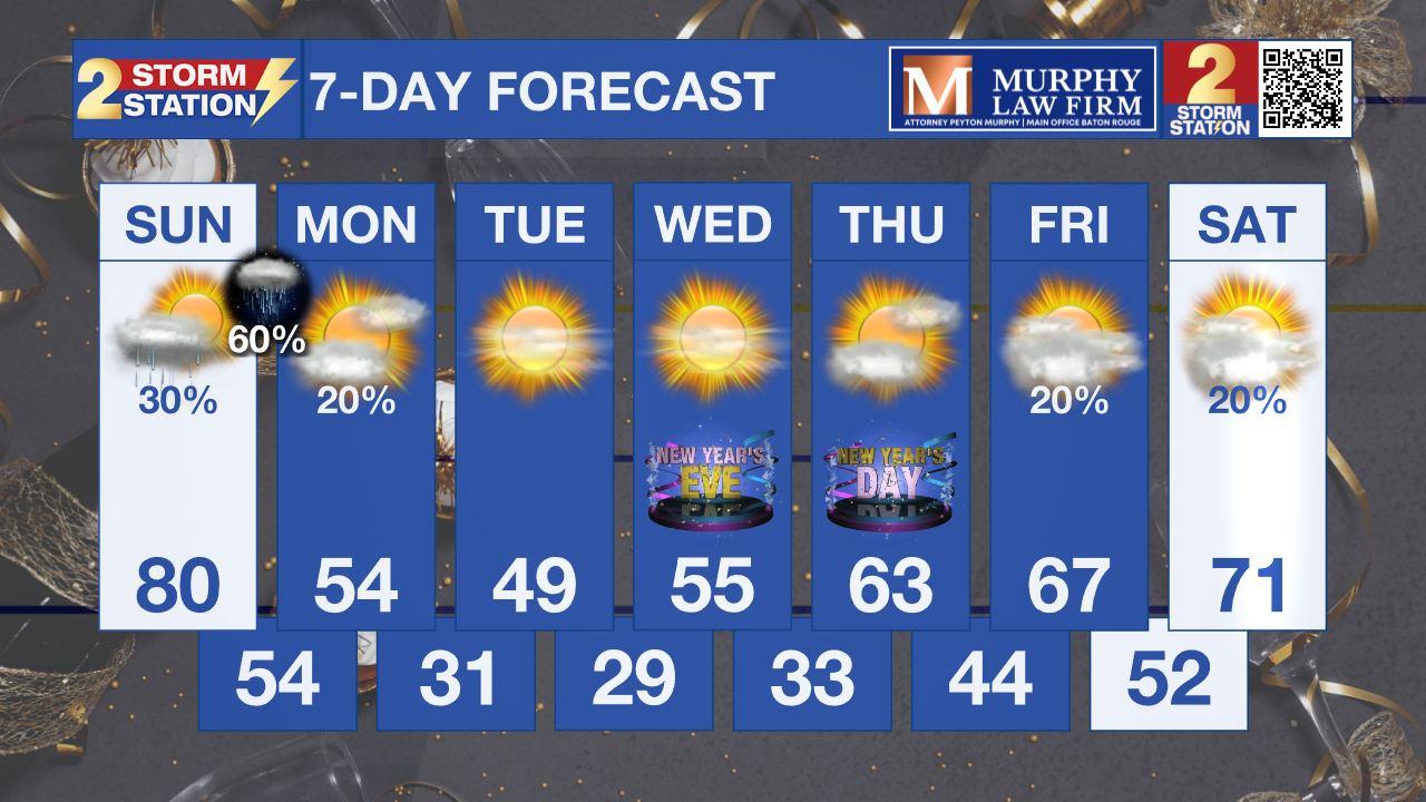
Cold conditions persist into midweek before a gradual warming trend develops later in the week and into the new year. While a few weak disturbances could bring spotty light showers later in the week, temperatures are expected to rebound back into the 70s by next weekend.
Get the latest 7-day forecast and real-time weather updates HERE.
Watch live news HERE.
– Dave
The Storm Station is here for you, on every platform. Your weather updates can be found on News 2, wbrz.com, and the WBRZ WX App on your Apple or Android device. Follow WBRZ Weather on Facebook and X for even more weather updates while you are on the go.
More News
