

Latest Weather Blog
Sunday AM Forecast: Cooler temperatures for the start of the workweek
Fall pattern staying locked in.
THE FORECAST
Today & Tonight: Cool, crisp morning with temperatures waking up in the low-50s. The northeasterly light breeze is expected to continue again today, pumping cooler, drier air into the forecast. Daytime highs will top out in the mid-80s. Warmer temperatures will not feel as hot with dew points on the low side again today. Completely clear skies expected throughout the day today and into the overnight hours. The upper-level system is not expected to change anytime soon locking us in this fall pattern, the complaint department is closed.
Up Next: To start the workweek, Monday will be a near repeat of the weekend, with morning temperatures in the low-50s and afternoon highs in the low-80s. Some light wispy cirrus clouds expected to start moving into the area later in the day on Monday. Humidity starts to creep back into the forecast and we will see dew points continue to rise throughout the week. Temperatures are expected to gradually rise as we go throughout the workweek as well. Daytime highs will be topping out in the mid-to-high-80s by next weekend. Some clouds will begin to build into the forecast as the winds start to shift. No rain in the forecast but just a little more fair weather clouds expected in the afternoons. Click here to see the 7-day forecast.
The Storm Station has you covered with hour-by-hour weather tracking is available for your location on the WBRZ WX App on your Apple or Android device. Follow WBRZ Weather on Facebook and Twitter for even more weather updates and unique weather insight from the whole team!
In the Tropics:
Trending News
The Storm Station is going to continue to monitor the development of these two systems. No current threats to the Gulf coast for the next 5 days.
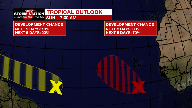
Eastern Tropical Atlantic:
A tropical wave located several hundred miles south of the Cabo
Verde Islands continues to produce disorganized showers and
thunderstorms. Environmental conditions are forecast to be favorable
for some gradual development during the next several days.
Therefore, a tropical depression is likely to form during the early
or middle part of next week while the system moves westward, then
turns northwestward or northward toward the end of the week over the
eastern tropical Atlantic.
* Formation chance through 48 hours...low...30 percent.
* Formation chance through 5 days...high...70 percent.
Central Tropical Atlantic:
Shower and thunderstorm activity associated with a tropical wave
located several hundred miles east of the Windward Islands has
increased over the past day or so. Some gradual development of the
wave is possible during the next few days while it moves generally
westward at 15 to 20 mph.
* Formation chance through 48 hours...low...10 percent.
* Formation chance through 5 days...low...20 percent.
More News
