

Latest Weather Blog
Saturday PM Forecast: Very cold temperatures tonight, big temperature swing will start next week
Cold temperatures will last through the rest of the weekend. Temperatures will climb drastically at the beginning of next week in advance of our next storm system.
A ***HARD FREEZE WARNING*** is in effect Saturday night into Sunday morning for parishes and counties along and north of Interstates 10/12. This includes all viewing area parishes and counties except Assumption, St. James, and St. Mary. Below freezing temperatures in the mid to lower 20s will cause conditions that could kill crops, other sensitive vegetation and possibly damage unprotected outdoor plumbing.
Take steps to protect tender plants from the cold. If you haven't already today, outdoor water pipes should be wrapped, drained, or allowed to drip slowly. Those that have in-ground sprinkler systems should drain them and cover above-ground pipes to protect them from freezing.
A ***WIND CHILL ADVISORY*** is in effect from midnight until 9am Sunday. Wind chills could be as low as 10 degrees across portions of southeast Louisiana and southern Mississippi that are generally along and north of the Interstate 10/12 corridor. Very cold temperatures and wind chills can lead to hypothermia if proper clothing is not worn. Use caution while traveling outside. Wear appropriate clothing, a hat, and gloves.
Tonight & Tomorrow: Temperatures will quickly fall tonight before reaching the mid 20's in the morning. Make sure you are bundled up when heading out the door tomorrow morning as it will be very cold. Tomorrow will be a touch warmer than it was today, but it will still be chilly with highs maxing out around 51 degrees. There also will be some high clouds mixing in with the sunshine.
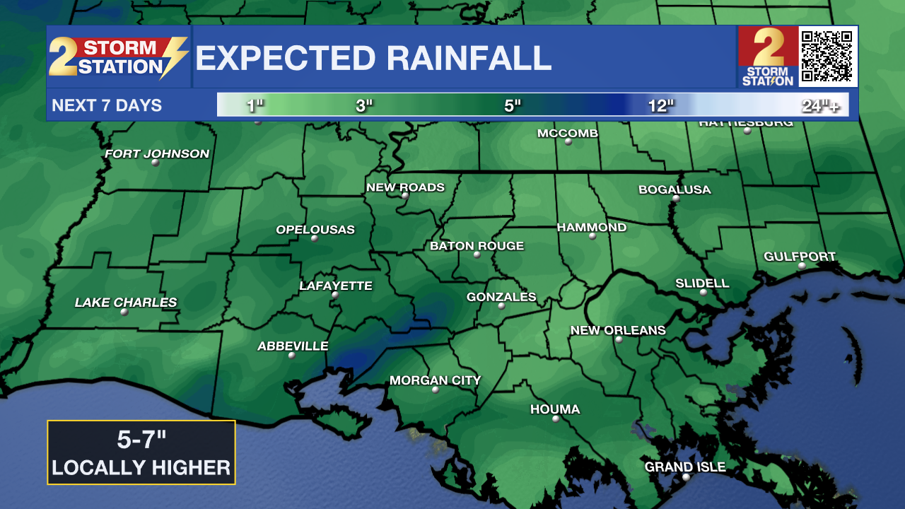
Up Next: Cloud cover will build substantially after dark on Sunday. This will be the beginning of a significant pattern change. Highs are expected to be near 70 degrees and above for multiple days next week. Rain will also be likely for multiple days in a row. This rain will likely come in multiple rounds with dry periods in between. While showers are generally expected for most of this activity, Wednesday looks to be the best day for thunderstorms. It is also possible that some of these thunderstorms could be on the stronger side. Through the end of the week, 5-7 inches of rain may fall with isolated higher totals. Such amounts could cause some flooding issues, so stay in touch with the forecast.
Trending News
Get the latest 7-day forecast and real time weather updates HERE.
Watch live news HERE.
– Balin
The Storm Station is here for you, on every platform. Your weather updates can be found on News 2, wbrz.com, and the WBRZ WX App on your Apple or Android device. Follow WBRZ Weather on Facebook and Twitter for even more weather updates while you are on the go.
More News
