

Latest Weather Blog
Quiet ahead of a long unsettled stretch of weather
There is nothing unusual on the weather side of things to start the week. Sunshine and mild temperatures will continue with humidity fairly low. Rain and storms will return by midweek and last into the weekend.
THE FORECAST:
Today and Tonight: Areas of patchy fog will dissipate by mid-morning and sunny skies will prevail through afternoon. Only some high, thin clouds will mix in at times. Temperatures will warm to 80 by late morning and top out in the upper 80s by mid-afternoon. A few clouds may be present on an otherwise quiet night with low temperatures in the mid 60s.
Up Next: Clouds will continue to increase on Tuesday as a warm front pushes into the western Gulf of Mexico. That boundary will allow showers and thunderstorms to push in from the southwest Tuesday night. Another front will settle in from the northwest and stall for several days, keeping conditions unsettled right into next weekend. Though timing is a lower confidence forecast at this time, Friday into Saturday look like the most stormy period. Several inches of rain may fall through Sunday, however segmenting the rain over several days should keep major flooding issues lower. Still, it is the Gulf Coast, so some spots of street and poor drainage flooding are to be expected. By virtue of clouds and precipitation, low temperatures should remain above average while high temperatures are near or just below average.
The Mississippi River: At Baton Rouge, major flood stage continues with a level of 41.7’ as of Monday morning. Peaking at 44.1’ on March 19, the river set its 7th highest recorded crest at Baton Rouge. In addition, at 121 days this marks the second longest period above flood stage. Heavy rain that fell north of the area will keep the river high through Mid-May. At about 42.5’, it does not appear that this second crest will be quite as high as the first earlier this year. The high water is primarily an issue for river traffic and river islands, although some inundation will continue unprotected low-lying areas. The city of Baton Rouge and the main LSU campus are protected by levees up to 47 feet. Some soggy areas and seepage may be noted due to the long duration of high water placing pressure on the levees. As some of the Mississippi River diverts into the Atchafalaya River, gauges at Krotz Springs and Morgan City will stay high as well. This creates backwater flooding in parts of Assumption Parish in areas such as Stephensville and around Lake Palourde. Like Big Muddy, this is expected to be a prolonged event but is not uncommon for the time of year.
THE EXPLANATION:
An upper level ridge and surface high pressure system moving across the Ohio River Valley will continue mainly clear skies and seasonably warm temperatures through Monday. By Tuesday with more persistent and deeper onshore flow from the Gulf of Mexico, expect dew point temperatures and therefore humidity to increase. With the ridge departing, some clouds will build in from the west as well. An unsettled stretch of weather will be underway by Wednesday morning. A warm front will be sliding in from the southwest as a broad upper level trough develops over the western two-thirds of the country. An associated weak cold front will move in from the northwest, stall, and become more diffuse. The position of this trough will put the local area under deep, southwest wind flow, which is a setup that favors rounds of rain and thunderstorms—especially with a forcing mechanism present in the form of a stalled front. This pattern will likely continue right into the upcoming weekend. There are two difficulties in this type pattern though. First will be timing out when the most active periods will occur and second will be placing the heaviest amounts of rain. As subtle upper level disturbances ride over the area, we can expect more action so this means daytime heating will not be the main factor in setting off precipitation.
Trending News
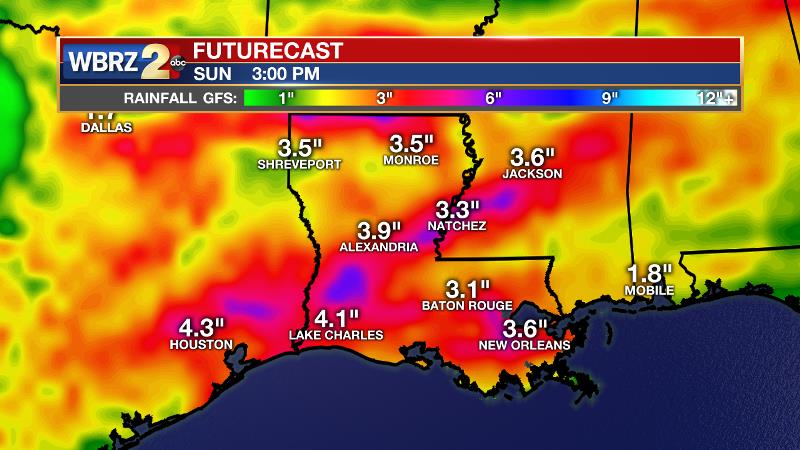
We are expecting a general 3-4 inches of rain over the area but along the Gulf Coast, an event like this often leads to isolated amounts that are quite a bit higher. The good news is that those amounts should be spread across 5 days, which should make runoff manageable, but it would not be surprising to see some areas of street and poor drainage flooding.
--Josh
The WBRZ Weather Team is here for you, on every platform. Your weather updates can be found on News 2, wbrz.com, and the WBRZ WX App. on Apple and Android devices. Follow WBRZ Weather on Facebook and Twitter for even more weather updates while you are on the go.
More News
