Monday PM Forecast: comfortable air slowly exiting this week
After a weekend of low humidity and dry conditions, a slow return to stickiness is ahead. By the middle of the week, a few showers will become possible as well.
Tonight & Tomorrow: Beneath mostly clear skies, it will remain comfortable and seasonable overnight. Low temperatures will bottom out right around 70 degrees. Areas north of I-12 will clip the upper 60s with coastal sections staying in the mid 70s. For Tuesday, look for ample sunshine early. As thermometers climb, so will a few cumulus clouds. One or two could even grow tall enough to squeeze out a stray shower. High temperatures will top out in the mid 90s and humidity will become noticeable once again as well.
Up Next: A weak cold front will arrive in the Capital Area on Wednesday. By this time, there will be enough moisture back in the atmosphere for some showers to develop. Through the end of the workweek, no single day looks particularly busy, but we will carry a mention of a spotty shower or thunderstorm in the forecast. Otherwise, expect partly sunny skies with highs in the low 90s and lows in the low 70s. Another front will push in for the weekend and should bring a better shot at showers and thunderstorms followed by lower humidity. Since this is farther out in the forecast range, stay in touch for the fine tuned details!
Get the latest 7-day forecast and real time weather updates HERE.
Watch live news HERE.
Trending News

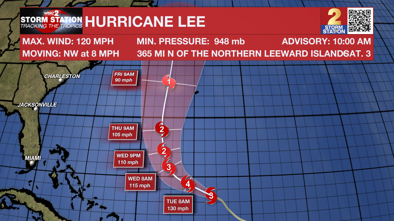
The Tropics: Hurricane Lee remains a major hurricane across the southwest Atlantic Ocean. The storm is expected to strengthen a bit more while turning north toward the middle of the week. It will then pass east of the United States and likely west of Bermuda, but it is too early to rule out impacts to the island. Dangerous surf is expected all across the Atlantic Seaboard. Lee will gradually weaken through the end of the week as it moves farther north.
Hurricane Margot has become the fifth hurricane of the season across the open, eastern Atlantic. The storm will continue northward as a hurricane for a few days later this week while posing no threat to land.
A weak area of low pressure located several hundred miles west-southwest of the Cabo Verde Islands is producing disorganized shower and thunderstorm activity. Development of this system is unlikely before it merges with a tropical wave incoming from the east during the next couple of days.
A tropical wave located over the far eastern tropical Atlantic between the Cabo Verde Islands and the west coast of Africa is producing disorganized showers and thunderstorms. Environmental conditions appear conducive for gradual development of this system, and there is a sixty percent chance that a tropical depression could form by the weekend while it moves westward to west-northwestward at 15 to 20 mph over the central tropical Atlantic.
--Josh
The Storm Station is here for you, on every platform. Your weather updates can be found on News 2, wbrz.com, and the WBRZ WX App on your Apple or Android device. Follow WBRZ Weather on Facebook and Twitter for even more weather updates while you are on the go.


