

Latest Weather Blog
Monday Evening Forecast: even wetter to start the week
Through Sunday (July 18), 2021 has been the wettest year on record. With rain totals approaching 5 feet, a few more inches are expected this week.
Next 24 Hours: Unlike last week, scattered showers and thunderstorms will continue overnight thanks to an upper level disturbance riding over the area. There will be breaks but do not be caught off guard by some loud pops of thunder and downpours. Lows will be steady in the low 70s. Especially early Tuesday, showers and thunderstorms will continue. Widespread flooding is not a concern, but street and poor drainage flooding can develop over very small areas affected but storm downpours. Highs will be limited to the mid 80s due to times of rain and thicker clouds.
Up Next: A culprit upper level disturbance and associated weak front will begin to fall apart Wednesday, but should still have enough influence on the weather pattern to keep widespread showers and thunderstorms around. Over the three days stretch, most locations will pick up between 1 and 3 inches of rain with locally higher amounts possible. By Thursday and Friday, activity will be categorized as more “normal” for the time of year with just isolated, afternoon showers. Keep in mind, drier times in the summer usually mean much more heat and steam. CLICK HERE for your full 7-Day Forecast.
There are signs that an overall, long-term drier pattern could be in store soon. But hopefully not too soon, according to the WBRZ Weather Team. CLICK HERE to read more as NOAA expects La Niña to develop by fall or winter.
The Tropics: For the North Atlantic, Caribbean Sea and Gulf of Mexico, no tropical development is expected over the next five days. For the latest tropical forecasts and information, visit the WBRZ Hurricane Center as we navigate all 183 Days of Hurricane Season.
The Explanation: The unusually persistent upper level trough draped across the Eastern U.S. will continue, and even deepen across the Mid-South this week, leading to a continued wet and stormy pattern. The trough is expected to drift southwest from the Mid-Mississippi River Valley to Texas through Wednesday before eventually being absorbed by the jet stream. There is a weak front associated with the upper level trough that will make little progress south from the Arkansas/Louisiana border to perhaps I-20 in that time. All the while, atmospheric moisture remains well above average. Unlike last week, because there will be waves of energy circling this upper level trough, bouts of showers and thunderstorms can be expected, even during the overnight hours. Though widespread flooding is not a concern, with 1 to 3 inches in the forecast through Wednesday, some localized street and poor drainage flooding is always possible.
Trending News
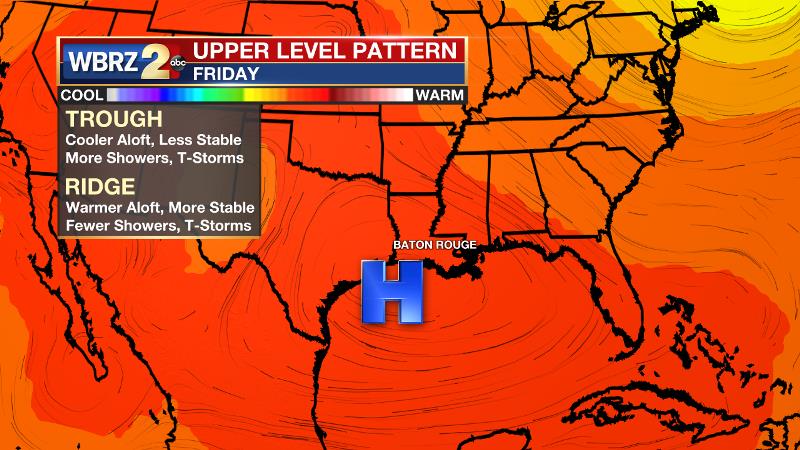
An upper level ridge will finally begin to build over the local area on Thursday and especially Friday. Since atmospheric moisture will stay elevated, showers and thunderstorms will not end entirely, but should be much more isolated and limited to the peak heating hours of the afternoon. It is not yet clear if those trends will hold through the weekend, but in any of the outcomes that seem plausible at this time, it is not expected to be as wet as the start of this week.
--Josh
The WBRZ Weather Team is here for you, on every platform. Your weather updates can be found on News 2, wbrz.com, and the WBRZ WX App on your Apple or Android device. Follow WBRZ Weather on Facebook and Twitter for even more weather updates while you are on the go.
More News
