

Latest Weather Blog
Monday AM Forecast: Foggy start to the week, Severe risk returns on Wednesday
The next risk for severe weather comes with a line of storms on Wednesday.
THE FORECAST
Today & Tonight: Take it slow this morning as foggy conditions will last through about 9 a.m. All areas are under a Dense Fog Advisory. Traffic over bridges will likely be moving slower until the fog lifts. This afternoon will be sunny and warm with temperatures climbing into the mid-80s. That summertime humidity is starting to make a comeback. You will feel some of those muggies this afternoon and muggy conditions will keep temperatures warm, in the low 60s tonight.
*DENSE FOG ADVISORY* for the shaded area. Take it easy driving and check with @WBRZtraffic for updates. #lawx #mswx pic.twitter.com/xLxyIgC9mN
— WBRZ Weather (@WBRZweather) March 28, 2022
Tuesday: Tuesday will be a near repeat of Monday. Some patchy to dense fog may be out there early and then the sun will come out. Mostly sunny skies will bring temperatures again into the mid-80s and overnight temperatures will be in the mid-60s.
Trending News
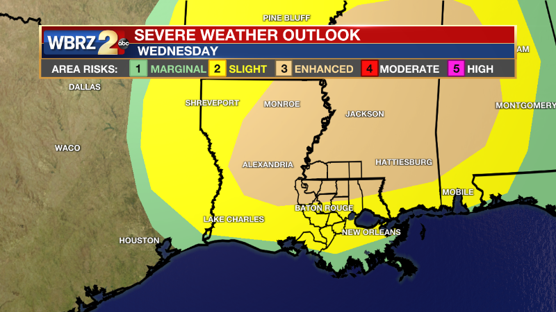
Wednesday: The WBRZ viewing area is under a level 2-3 severe risk. The level 3/5 ENHANCED RISK is maximized north, in Mississippi, but areas north of Baton Rouge are included in this risk category. South of Baton Rouge is included in the level 2/5 SLIGHT RISK. All areas are at risk for strong storms with winds gusting between 60-75mph+. Large hail, a few tornadoes, and localized flooding will also be a possibility.
A line of storms will approach the area around 2p.m. and it will be stormy in the Baton Rouge area until about 8 p.m. This timeline will likely shift. Stay connected for updated forecasts.
Up Next: Thursday will be a bit cooler behind Wednesday’s storms. Morning temperatures will be in the 50s and the afternoon will be partly cloudy with temperatures in the mid-70s. Friday will be similar with morning temperatures in the 50s and afternoon conditions partly cloudy with temperatures in the mid-70s. On Saturday, a round of showers and storms will roll through. At this time, there is no severe weather risk, but a few rumbles of thunder will be around. The second half of the weekend is looking clear and comfortable with temperatures in the 70s. Click here to see the 7-day forecast.
Reminder: With the threat for impactful weather— Severe Storms—please have access to alerts through Wednesday. You can download or activate the WBRZ WX App on your Apple or Android device or turn on a NOAA Weather Radio for bulletins such as watches and urgent warnings. Of course, WBRZ, WBRZ+ and the Cable Weather Channel will have updates as active weather dictates.
More News
