

Latest Weather Blog
Friday PM Weather Blog: Fred, soon-to-be Grace and a summery weekend
You know how it goes; sun until lunchtime followed by afternoon clouds, showers and thunderstorms up to sunset. In addition to Fred, we are now monitoring what is expected to become Tropical Storm Grace over the weekend.
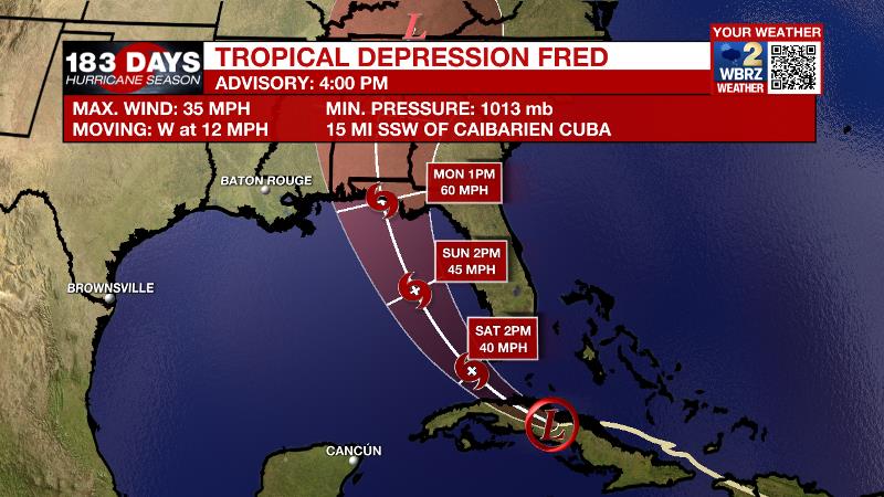
The Tropics: As of 4pm Friday, Tropical Depression Fred was near central Cuba producing maximum winds of 35mph and moving to the west-northwest at 12mph. Fred remained a poorly organized system struggling with wind shear and land despite some warm water to fuel development. Fred will begin to turn northwest between Cuba and south Florida on Saturday. Conditions may improve modestly and allow Fred to become a tropical storm by that time. It is expected to pass west of the peninsula on Sunday before making landfall in the Florida Panhandle early Monday morning. The main threat to land will be flash flooding due to heavy rain.
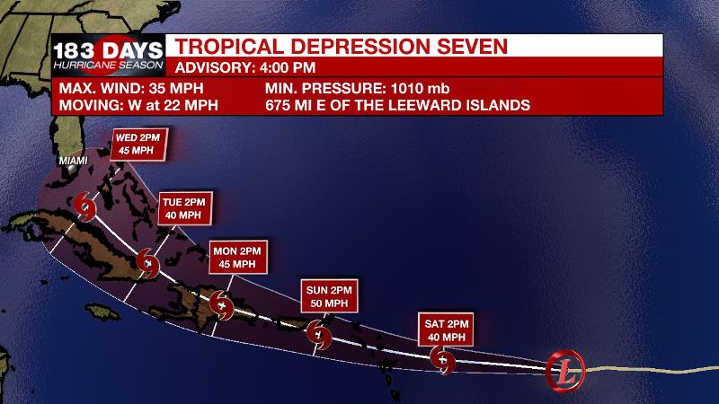
As of 4pm Friday, Tropical Depression Seven was located midway between Africa and the Lesser Antilles with maximum winds of 35mph. Seven will continue to race westward at 21mph over the weekend. Some gradual strengthening is expected and Tropical Storm Grace is likely to form over the weekend. This system is too far away to anticipate any impacts to the United States.
Trending News
For the latest tropical forecasts, advisories and information, visit the WBRZ Hurricane Center as we navigate all 183 Days of Hurricane Season.
Next 24 Hours: As showers end and skies clear, overnight low temperatures will move down into the low to mid 70s. We will hit the weekend with a continuation of the summer weather pattern. On Saturday, morning sunshine will push high temperatures into the low 90s. By afternoon, the sea breeze will interact with the typical heat and humidity to produce scattered showers and thunderstorms.
Up Next: Sunday will offer much of the same. By Monday and Tuesday, a bit more instability and moisture than the previous couple of days could result in more, perhaps widespread, showers and thunderstorms. For the 13 Parish, 3 County Forecast Area, rain coverage will be around 50 to 70 percent. One or two storms could cause minor street and poor drainage flooding in addition to frequent lightning. As for temperatures, highs may stop shy of 90 with lows near 75. By the middle and end of next week, signs point to slightly drier weather resulting in highs reaching the mid 90s. CLICK HERE for your full 7-Day Forecast.
The Explanation: The local area is beneath a weakness between two upper level ridges. The area of relatively low subsidence (sinking air) leaves little inhibition for showers and thunderstorms to bubble up on the regular. Through Sunday, expect scattered, afternoon showers and thunderstorms to pop and drift after midday highs near 90 degrees. With rain and cloud relief in the afternoons, the heat index could top out around 105 degrees but will not last very long. It still appears as though Tropical Storm Fred will have little to no impact on the local area. A developing upper level trough, which will help to keep Fred just east of Louisiana and Mississippi, will also destabilize the local atmosphere even more as deep moisture remains in place. The result of these factors will be even more of an uptick in showers and thunderstorms, especially Monday and Tuesday. Later next week, as this upper trough retreats, the atmosphere may warm up translating into a little less convection and higher high temperatures. Overall, not much change to the pattern is expected.
--Josh
The WBRZ Weather Team is here for you, on every platform. Your weather updates can be found on News 2, wbrz.com, and the WBRZ WX App on your Apple or Android device. Follow WBRZ Weather on Facebook and Twitter for even more weather updates while you are on the go.
More News
