

Latest Weather Blog
Wednesday PM Forecast: drying out before dawn
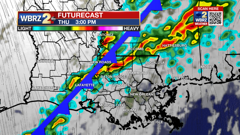
After showers and thunderstorms end from west to east overnight, some clearing is expected into Thursday. A substantial change has been made to the forecast for Friday.
Tonight & Tomorrow: Remaining rain will move east of I-55 after midnight. Low temperatures will bottom out in the low 50s. The cold front is expected to slow down just east of the Metro Area and so clouds may linger over some areas Thursday, especially south and east of Baton Rouge. High temperatures will stay a few degrees above average, in the upper 60s.
Up Next: With the recent front stalled near the coast, an area of low pressure will develop ahead of a secondary cold front approaching the area. Due to this, mostly cloudy skies and even some showers have been introduced to the forecast for Friday. Once that second front passes through, much colder air will push in for the weekend.
A little bit of moisture wrapping around behind the front could even cause some lingering drizzle in the morning and clouds for a lot of the day. As a result, plan to bundle for Mardi Gras parades with highs barely in the 50s followed by a night with lows in the 30s. Clear and dry conditions are anticipated for Sunday.
Trending News
Get the latest 7-day forecast and real time weather updates HERE.
Watch live news HERE.
Detailed Forecast: The cold front moving into the region tonight will just barely make it through the forecast area on Thursday. With upper level winds staying out of the southwest and parallel to the front, lingering clouds and showers will be possible for areas south and east of Baton Rouge. Some cooler air will trail the front, but temperatures will remain above average. Another upper level trough of low pressure will dig into the Lower Midwest on Thursday night. This feature will induce a weak surface low which will ride northeastward across the region on Friday. A pocket of rain may accompany this low for the final day of the workweek. The associated secondary cold front will then start to push through on Saturday. With moisture wrapping around the backside of the surface low, cloud cover may be slow to break making high temperatures struggle to reach the 50s on Saturday. It will be uncomfortable to be outside. Clear skies will help temperatures cool further into Sunday morning. If winds go below 5mph, then a light freeze will be possible north of the interstate highways. Sunday will remain cool, but will feel much more comfortable with sunshine and light winds. A warming trend begins on Monday as a surface high shifts eastward ahead of the next system on Tuesday. Another cold front is expected on Tuesday with rain and thunderstorms.
--Josh
The Storm Station is here for you, on every platform. Your weather updates can be found on News 2, wbrz.com, and the WBRZ WX App on your Apple or Android device. Follow WBRZ Weather on Facebook and Twitter for even more weather updates while you are on the go.
More News
