

Latest Weather Blog
Cold Weather Advisory issued ahead of arctic plunge
A *Cold Weather Advisory* has been issued from 9 p.m. Sunday until 9 a.m. Monday. Very cold wind chills ranging from 12 to 20 degrees will impact locations along and north of the Interstate 10/12 corridor. Wind chills of 20 to 25 degrees will affect locations south of this corridor. These types of wind chill values can lead to hypothermia with prolonged exposure. Use caution while traveling outside and wear appropriate clothing. Keep pets indoors as much as possible. Make frequent checks on older family, friends, and neighbors. Ensure portable heaters are used correctly. Do not use generators or grills inside.
Arctic Blast: A very strong cold front is on its final approach and will arrive during the overnight hours, first bringing a round of numerous showers and thunderstorms. The best chance of rain will be between midnight and 4 a.m. By daybreak, only a few lingering showers will remain, but clouds will hold steady. Lows will bottom out in the mid-50s, which will also be the high for the day. Temperatures will remain steady, and could even slowly fall throughout the afternoon. We will quickly slip into the 30s shortly after sunset.
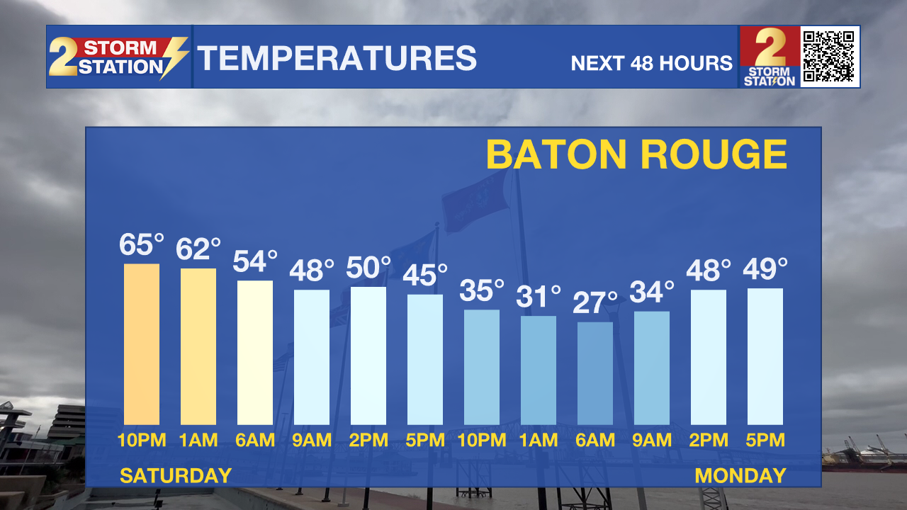
Although clouds will be widespread during the morning, expect considerable clearing by the afternoon and evening. Winds will be quite breezy, sustained at 10–15 mph with gusts up to 25 mph, making it feel 5–10 degrees colder than the actual temperature.
The coldest air of the season so far moves in overnight, with widespread freezing conditions expected. Many locations will drop into the 20s, and some areas—especially north and east of Baton Rouge—may reach the low to mid-20s. Be sure to protect the four P’s: pets, pipes, people, and plants. Even with plenty of sunshine on Monday, highs will struggle to climb out of the 40s. Another round of freezing temperatures is likely early Tuesday before a steady warmup takes over.
Trending News


Use the slider to advance through the next 24 hours of Futurecast
Up Next: Temperatures will steadily warm through the rest of the week. Highs will rebound into the 70s by Wednesday, with lows climbing into the upper 40s and then into the 50s afterward. While a few showers are possible starting Wednesday, no significant rainmaker is expected.
Get the latest 7-day forecast and real-time weather updates HERE.
Watch live news HERE.
– Balin
The Storm Station is here for you, on every platform. Your weather updates can be found on News 2, wbrz.com, and the WBRZ WX App on your Apple or Android device. Follow WBRZ Weather on Facebook and X for even more weather updates while you are on the go.
More News
